SHOP BY YEAR :: FOR OFFICE :: FOR CLASSROOM :: GIFT IDEAS :: CUSTOMER SERVICE

Ruysch 1508 Map
Issue: April 1893
More Views
Enlarge Image
ZoomClick here to zoom!
Purchase Product :
Please select map format:
Laminated   
23" x 18" - $19.95
Laminated-w/Plastic Rails  (What are rails?)
23" x 18" - $29.95
Paper
23" x 18" - $14.95
Wallzilla Adhesive Format
23" x 18" - $34.95
Product Highlights
Ruysch 1508 Map
Item#: X NGC 041893a

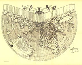
One of the first maps of the new world, Johannes Ruysch made this map, using a polar projection, which includes an extensive view of South America, islands of the West Indies, and a portion of North America. The World Map from Ruysch appeared for the first time among the Tabulae Novae in some copies of the 1507 Rome edition of Ptolemys Geography. Ruyschs map illustrates a number of significant geographic features more correctly than before, especially along the easterly sea route to the Orient which was of prime importance to early sixteenth-century Europeans. An incredible historical piece.

The 1893 Ruysch map, originally published in 1508, features:
• One of the first known views of the new world
• Views of South America, islands of the West Indies, and a portion of North America
• The exciting new world discoveries of the late fifteenth century
• Polar projection that acknowledges the belief that the northern passage was yet to be discovered
• One of the most detailed maps of India at the time

Coverage Area: Portion of North America, South America, West Indies, Africa, Atlantic Ocean, India

More Product Details

This map requires 7 business days to print and laminate prior to shipping.

Appearing in the April 1893 issue of the National Geographic Magazine, this Ruysch Map, 1508 map has been reproduced from its original cartography in order to bring to life a beautiful poster previously only seen in National Geographic Magazine. This reproduction holds true to the high standards that National Geographic Maps are known for.

Perfect for home, office or classroom, this map also makes a great gift. Map collectors will surely want to add this map to their library.

The Paper version is printed on high quaility semi-gloss paper, perfect for framing.

The Laminated version uses 3mm laminate on both sides for durability, is easy to clean and markable.

From the National Geographic Classic Maps collection, this reproduction is just one of hundreds of titles available here. These maps are Printed on Demand. Sizes are approximate and may vary due to the nature of the trimming and laminating processes.
Shipping Conditions
Maps.com ships to Dometic US only

US FlagThis product can only be shipped to the Domestic U.S.A. (No APO's or PO Boxes)
TimeThis map requires 2 business days to print and laminate prior to shipping.