SHOP BY YEAR :: FOR OFFICE :: FOR CLASSROOM :: GIFT IDEAS :: CUSTOMER SERVICE

World Map 1951
Issue: December 1951
More Views
Enlarge Image
ZoomClick here to zoom!
Purchase Product :
Please select map format:
Laminated   
42" x 27.5" - $59.95
Laminated-w/Plastic Rails  (What are rails?)
42" x 27.5" - $76.95
Paper
42" x 27.5" - $49.95
Wallzilla Adhesive Format
42" x 27.5" - $89.95
Product Highlights
World Map 1951
Item#: X NGC 121951

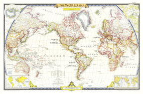
The first World Map published by National Geographic following WWII, this classic is a perfect companion to the World Map published in December 1943. The brightness of this map communicates the optimism following WWII, with an inset showing the United Nations, along with a list of the nations who had joined as of December 1951.

The 1951 World map features:
• International boundaries reflecting the changes following WWII
• Insets for Antarctica and the Arctic
• An inset showing the United Nations countries, along with a list of the countries.
• The inset also shows the Communist World, and Atlantic Pact countries
• Major cities and capitals
• Rail routes, major roads
• Ocean currents are shown on the map

Coverage Area: The World, North America, South America, Africa, Asia, Australia, Europe, Oceania, Antarctica

More Product Details

This map requires 7 business days to print and laminate prior to shipping.

Appearing in the December 1951 issue of the National Geographic Magazine, this World Map map has been reproduced from its original cartography in order to bring to life a beautiful poster previously only seen in National Geographic Magazine. This reproduction holds true to the high standards that National Geographic Maps are known for.

Perfect for home, office or classroom, this map also makes a great gift. Map collectors will surely want to add this map to their library.

The Paper version is printed on high quaility semi-gloss paper, perfect for framing.

The Laminated version uses 3mm laminate on both sides for durability, is easy to clean and markable.

From the National Geographic Classic Maps collection, this reproduction is just one of hundreds of titles available here. These maps are Printed on Demand. Sizes are approximate and may vary due to the nature of the trimming and laminating processes.
Shipping Conditions
Maps.com ships to Dometic US only

US FlagThis product can only be shipped to the Domestic U.S.A. (No APO's or PO Boxes)
TimeThis map requires 2 business days to print and laminate prior to shipping.