SHOP BY YEAR :: FOR OFFICE :: FOR CLASSROOM :: GIFT IDEAS :: CUSTOMER SERVICE

United States Of America Map 1892
Issue: March 1892
More Views
Enlarge Image
ZoomClick here to zoom!
Purchase Product :
Please select map format:
Laminated   
17" x 12" - $19.95
Laminated-w/Plastic Rails  (What are rails?)
17" x 12" - $29.95
Paper
17" x 12" - $14.95
Wallzilla Adhesive Format
17" x 12" - $34.95
Product Highlights
United States Of America Map 1892
Item#: X NGC 031892b

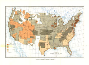
Most cartographers will tell you that a map is only as good as the source information from which it is gathered. This United States map, first published in March of 1892, shows the US with an overlay describing the relative quality of source maps, or "Mother Maps" available at that time for various sections of the country. The map was painstakingly compiled by mapping pioneer Henry Gannett of the US Geological Survey.

The 1892 United States map features:
• A US map showing the 48 states
• Color-coded areas depicting the qualtiy of the "Mother Maps" available for each area
• Major cities and waterways

Coverage Area: United States, northern Mexico, southern Canada

More Product Details

This map requires 7 business days to print and laminate prior to shipping.

Appearing in the March 1892 issue of the National Geographic Magazine, this United States Of America map has been reproduced from its original cartography in order to bring to life a beautiful poster previously only seen in National Geographic Magazine. This reproduction holds true to the high standards that National Geographic Maps are known for.

Perfect for home, office or classroom, this map also makes a great gift. Map collectors will surely want to add this map to their library.

The Paper version is printed on high quaility semi-gloss paper, perfect for framing.

The Laminated version uses 3mm laminate on both sides for durability, is easy to clean and markable.

From the National Geographic Classic Maps collection, this reproduction is just one of hundreds of titles available here. These maps are Printed on Demand. Sizes are approximate and may vary due to the nature of the trimming and laminating processes.
Shipping Conditions
Maps.com ships to Dometic US only

US FlagThis product can only be shipped to the Domestic U.S.A. (No APO's or PO Boxes)
TimeThis map requires 2 business days to print and laminate prior to shipping.