SHOP BY YEAR :: FOR OFFICE :: FOR CLASSROOM :: GIFT IDEAS :: CUSTOMER SERVICE

United States Of America Map 1923
Issue: April 1923
More Views
Enlarge Image
ZoomClick here to zoom!
Purchase Product :
Please select map format:
Laminated   
38" x 28" - $59.95
Laminated-w/Plastic Rails  (What are rails?)
38" x 28" - $76.95
Paper
38" x 28" - $49.95
Wallzilla Adhesive Format
38" x 28" - $89.95
Product Highlights
United States Of America Map 1923
Item#: X NGC 041923

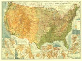
Long before Interstate highways criss-crossed the US, the nation was threaded together by highways with names like Lakes-to-Gulf Highway and King of Trails. Spectacular detail and artistry come together in this map--the first US map published by National Geographic. This beautiful US map, published in 1923, is a cartographic time capsule, and a must-have for any map collector.

The 1923 United States map features:
• Full coverage of the 48 states in 1923
• Beautiful hypsometric tints showing elevation across the country
• Thousands of place names, including state capitals
• City insets for Seatlle, Portland, San Francisco Bay Area, Los Angeles, Chicago, New Orleans, Baltimore, Washington DC, Detroit, Cleveland, Pittsburgh, Philadelphia, Buffalo, New York City, and Boston

Coverage Area: Continental US, southern Canada, Northern Mexico, Seatlle, Portland, San Francisco Bay Area, Los Angeles, Chicago, New Orleans, Baltimore, Washington DC, Detroit, Cleveland, Pittsburgh, Philadelphia, Buffalo, New York City, and Boston

More Product Details

This map requires 7 business days to print and laminate prior to shipping.

Appearing in the April 1923 issue of the National Geographic Magazine, this United States Of America map has been reproduced from its original cartography in order to bring to life a beautiful poster previously only seen in National Geographic Magazine. This reproduction holds true to the high standards that National Geographic Maps are known for.

Perfect for home, office or classroom, this map also makes a great gift. Map collectors will surely want to add this map to their library.

The Paper version is printed on high quaility semi-gloss paper, perfect for framing.

The Laminated version uses 3mm laminate on both sides for durability, is easy to clean and markable.

From the National Geographic Classic Maps collection, this reproduction is just one of hundreds of titles available here. These maps are Printed on Demand. Sizes are approximate and may vary due to the nature of the trimming and laminating processes.
Shipping Conditions
Maps.com ships to Dometic US only

US FlagThis product can only be shipped to the Domestic U.S.A. (No APO's or PO Boxes)
TimeThis map requires 2 business days to print and laminate prior to shipping.