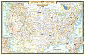
The Historical Map of the United States published in June 1953 accompanied six articles on the United States including "Founders of New England." A unique collectible, this map of the continental United States features a wealth of historical information, subtle relief shading, and details such as explorers' routes and immigrant trails. The 1953 Historical Map of the United States features:
• Inset map of the Central Atlantic states
• Inset map of the Northeastern states
• Growth of Our Country map which shows the phases of the county's growth from original colonies through the Gadsden Purchase from Mexico in 1853
• Explorers' routes and immigrant trails
• Historical notes, sites, and battlefields
• Selected cities and highways
• Mountain relief, geographical regions, major lakes, and rivers
Coverage Area: Continental United States, northern Mexico, southern Canada
|


 Click here to zoom!
