 |
|
|
|
|
USA Portrait Map 1976
Issue: July 1976
|
|
|
|
|
|
|
| Product Highlights |
| USA Portrait Map 1976 |
| Item#: X NGC 071976b |
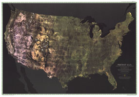
The first color satellite photomosaic of the 48 contiguous United States, this landmark map was published in July of 1976. The near-true color imagery showed the patchwork quilt of the contiguous 48 states as no image had done before. Trace the Mississippi river from its source to the Gulf of Mexico. See the deserts of New Mexico, Arizona, and California. Follow the Rocky Mountains through the western states. A cartographic benchmark, this map laid the groundwork for the many that have followed. The 1976 Portrait USA map features:
• Spectacular image of the 48 contiguous United States
• Near true color imagery shows all the natural features
• Rivers, mountain ranges, the midwest bread basket, lakes, deserts
• Incredible detailed imagery
Coverage Area: 48 contiguous United States
|
|
 |
More Product Details
This map requires 7 business days to print and laminate prior to shipping.
Appearing in the July 1976 issue of the National Geographic Magazine, this Portrait Usa map has been reproduced from its original cartography in order to bring to life a beautiful poster previously only seen in National Geographic Magazine. This reproduction holds true to the high standards that National Geographic Maps are known for.
Perfect for home, office or classroom, this map also makes a great gift. Map collectors will surely want to add this map to their library.
The Paper version is printed on high quaility semi-gloss paper, perfect for framing.
The Laminated version uses 3mm laminate on both sides for durability, is easy to clean and markable.
From the National Geographic Classic Maps collection, this reproduction is just one of hundreds of titles available here. These maps are Printed on Demand. Sizes are approximate and may vary due to the nature of the trimming and laminating processes.
|
|
Shipping Conditions
Maps.com ships to Dometic US only
 | This product can only be shipped to the Domestic U.S.A. (No APO's or PO Boxes) |  | This map requires 2 business days to print and laminate prior to shipping. |
|
|
|
|


 Click here to zoom!