 |
|
|
|
|
Americas Federal Lands Map 1982
Issue: September 1982
|
|
|
|
|
|
|
| Product Highlights |
| Americas Federal Lands Map 1982 |
| Item#: X NGC 091982b |
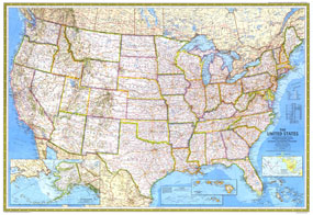
A third of the United States, nearly 740 million acres, remains in federal hands and there is constant debate over how to manage them. This map, published in September 1982 with the article "Our National Forests: Problems in Paradise" and as a companion to the map of the United States, features an abundance of information about land use and resources. The 1982 Americas Federal Lands map features:
• Wildlife refuges, national forests, national parks, Indian properties, BLM lands, military properties, offshore petroleum leases, and more
• Resource production divided into regions including the Pacific coast, Alaska and Hawaii; Rocky Mountain; Mid-continent; and Atlantic coast regions
• A map showing the resources extracted including coal, natural gas, petroleum, hardwood forest, mixed forest, and softwood forest on both public and private lands
• An abundance of information about the federals lands including some history of recent policy changes
• Information about federal lands in Alaska
Coverage Area: United States
|
|
 |
More Product Details
This map requires 7 business days to print and laminate prior to shipping.
Appearing in the September 1982 issue of the National Geographic Magazine, this Americas Federal Lands map has been reproduced from its original cartography in order to bring to life a beautiful poster previously only seen in National Geographic Magazine. This reproduction holds true to the high standards that National Geographic Maps are known for.
Perfect for home, office or classroom, this map also makes a great gift. Map collectors will surely want to add this map to their library.
The Paper version is printed on high quaility semi-gloss paper, perfect for framing.
The Laminated version uses 3mm laminate on both sides for durability, is easy to clean and markable.
From the National Geographic Classic Maps collection, this reproduction is just one of hundreds of titles available here. These maps are Printed on Demand. Sizes are approximate and may vary due to the nature of the trimming and laminating processes.
|
|
Shipping Conditions
Maps.com ships to Dometic US only
 | This product can only be shipped to the Domestic U.S.A. (No APO's or PO Boxes) |  | This map requires 2 business days to print and laminate prior to shipping. |
|
|
|
|


 Click here to zoom!