 |
|
|
|
|
United States, The Physical Landscape Map 1996
Issue: October 1996
|
|
|
|
|
|
|
| Product Highlights |
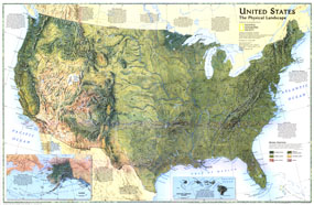
| United States, The Physical Landscape Map 1996 |
| Item#: X NGC 101996b |
A spectacular physical features portrait of the United States. This stunning map, published in October of 1996, compiled information gathered from multiple sources to create this look at the physical forces that have shaped our landscape. A companion to the Federal Lands map published the same month, this is a must have for anyone interested in geology or Earth Science. The 1996 United States Physical Landscape map features:
• Physical map of the United states
• A natural color landscape portrait that shows land features and vegetation
• Spectacular rendering of mountains, river valleys, plains, deserts, and lakes
• Major cities to provide geographic reference to the features of the map
• Rivers and river valleys are highlighted
• Descriptions of the natural forces that formed each of the major landscapes
• Insets of Hawaii and Alaska, along with descriptions of the natural forces that formed their landscapes
Coverage Area: United States
|
|
 |
More Product Details
This map requires 7 business days to print and laminate prior to shipping.
Appearing in the October 1996 issue of the National Geographic Magazine, this United States, The Physical Landscape map has been reproduced from its original cartography in order to bring to life a beautiful poster previously only seen in National Geographic Magazine. This reproduction holds true to the high standards that National Geographic Maps are known for.
Perfect for home, office or classroom, this map also makes a great gift. Map collectors will surely want to add this map to their library.
The Paper version is printed on high quaility semi-gloss paper, perfect for framing.
The Laminated version uses 3mm laminate on both sides for durability, is easy to clean and markable.
From the National Geographic Classic Maps collection, this reproduction is just one of hundreds of titles available here. These maps are Printed on Demand. Sizes are approximate and may vary due to the nature of the trimming and laminating processes.
|
|
Shipping Conditions
Maps.com ships to Dometic US only
 | This product can only be shipped to the Domestic U.S.A. (No APO's or PO Boxes) |  | This map requires 2 business days to print and laminate prior to shipping. |
|
|
|
|


 Click here to zoom!