SHOP BY YEAR :: FOR OFFICE :: FOR CLASSROOM :: GIFT IDEAS :: CUSTOMER SERVICE

United States Of America Map 1940
Issue: December 1940
More Views
Enlarge Image
ZoomClick here to zoom!
Purchase Product :
Please select map format:
Laminated   
41.5" x 27" - $59.95
Laminated-w/Plastic Rails  (What are rails?)
41.5" x 27" - $76.95
Paper
41.5" x 27" - $49.95
Wallzilla Adhesive Format
41.5" x 27" - $89.95
Product Highlights
United States Of America Map 1940
Item#: X NGC 121940

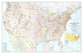
Great maps communicate something about the era in which they are published. This US map, first published in National Geographic in December of 1940, is a cartographic gem. This map included two insets that tell much about the time it was published. One inset shows the population shift between 1930 and 1940, following the devastation of the droughts of the 1930s. Another inset shows the Army Service Command Areas and Naval Districts as the US prepared to enter WWII. Any map collector will delight in the balance between features and extraordinary detail.

The 1940 United States map features:
• Thousands of cities and towns, classified by their population
• Road network easily identified against the light background
• Mountain ranges with beautiful relief shading
• Waterways, national parks, and national monuments
• Inset showing the population of all 48 states, and the gain or loss between 1930 and 1940
• Inset showing the Army Service Command Areas and Naval Districts across the US
• Excellent detail in northern Mexico and southern Canada

Coverage Area: United States, southern Canada, northern Mexico

More Product Details

This map requires 7 business days to print and laminate prior to shipping.

Appearing in the December 1940 issue of the National Geographic Magazine, this United States Of America map has been reproduced from its original cartography in order to bring to life a beautiful poster previously only seen in National Geographic Magazine. This reproduction holds true to the high standards that National Geographic Maps are known for.

Perfect for home, office or classroom, this map also makes a great gift. Map collectors will surely want to add this map to their library.

The Paper version is printed on high quaility semi-gloss paper, perfect for framing.

The Laminated version uses 3mm laminate on both sides for durability, is easy to clean and markable.

From the National Geographic Classic Maps collection, this reproduction is just one of hundreds of titles available here. These maps are Printed on Demand. Sizes are approximate and may vary due to the nature of the trimming and laminating processes.
Shipping Conditions
Maps.com ships to Dometic US only

US FlagThis product can only be shipped to the Domestic U.S.A. (No APO's or PO Boxes)
TimeThis map requires 2 business days to print and laminate prior to shipping.