SHOP BY YEAR :: FOR OFFICE :: FOR CLASSROOM :: GIFT IDEAS :: CUSTOMER SERVICE

Hawaii Map 1976
Issue: April 1976
More Views
Enlarge Image
ZoomClick here to zoom!
Purchase Product :
Please select map format:
Laminated   
35" x 22.5" - $39.95
Laminated-w/Plastic Rails  (What are rails?)
35" x 22.5" - $51.95
Paper
35" x 22.5" - $29.95
Wallzilla Adhesive Format
35" x 22.5" - $59.95
Product Highlights
Hawaii Map 1976
Item#: X NGC 041976a

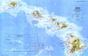
This detailed map of Hawaii was published in April 1976 as part of the "Close-up: U.S.A" series. Half of a two-map set, this map features national and state parks, volcanoes, and points of interest in addition to information on a variety of tourist activities and events.

The 1976 Hawaii map features:
• Inset map of the State of Hawaii which includes all islands and reefs in the chain
• Information on sites and events
• National parks, state historic parks and monuments, state scenic and recreational parks, wildlife refuges, government reservations, forest reserves, and points of interest
• Cities and towns
• Interstate highways, roads, recreational trails, and airports
• Coral reefs, lava, and swamps
• Ocean bathymetry, warm currents, and winds

Coverage Area: Hawaiian Islands, Hawaii, Kauai, Oahu, Molokai, Lanai, Maui, Niihau, Kahoolawe

More Product Details

This map requires 7 business days to print and laminate prior to shipping.

Appearing in the April 1976 issue of the National Geographic Magazine, this Hawaii map has been reproduced from its original cartography in order to bring to life a beautiful poster previously only seen in National Geographic Magazine. This reproduction holds true to the high standards that National Geographic Maps are known for.

Perfect for home, office or classroom, this map also makes a great gift. Map collectors will surely want to add this map to their library.

The Paper version is printed on high quaility semi-gloss paper, perfect for framing.

The Laminated version uses 3mm laminate on both sides for durability, is easy to clean and markable.

From the National Geographic Classic Maps collection, this reproduction is just one of hundreds of titles available here. These maps are Printed on Demand. Sizes are approximate and may vary due to the nature of the trimming and laminating processes.
Shipping Conditions
Maps.com ships to Dometic US only

US FlagThis product can only be shipped to the Domestic U.S.A. (No APO's or PO Boxes)
TimeThis map requires 2 business days to print and laminate prior to shipping.