 |
|
|
|
|
Coastal California Map 1993
Issue: July 1993
|
|
|
|
|
|
|
| Product Highlights |
| Coastal California Map 1993 |
| Item#: X NGC 071993b |
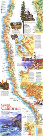
Published in July 1993 as half of a two-map set, this beautifully illustrated map of Coastal California highlights the sites and activities to be found along this extraordinary coastline. From the magnificent redwoods to the sunny beaches of San Diego, this map documents the diverse regions to be experienced along the coastline of the Golden State. The 1993 Coastal California map features:
• Inset map of the San Francisco Bay Area, Monterey, Los Angeles, and San Diego
• Information on each of the areas appearing in inset maps
• National forests, national parks, state parks, historica parks, state beaches, wildlife refuges, Indian reservations, missions, and U.S. government facilities
• Cities and towns
• Interstate highways, divided highways, roads, passenger railroads, airports, and international airports
• Beautiful illustrations of popular tourist sites
• Elevations in feet
Coverage Area: California
|
|
 |
More Product Details
This map requires 7 business days to print and laminate prior to shipping.
Appearing in the July 1993 issue of the National Geographic Magazine, this Coastal California map has been reproduced from its original cartography in order to bring to life a beautiful poster previously only seen in National Geographic Magazine. This reproduction holds true to the high standards that National Geographic Maps are known for.
Perfect for home, office or classroom, this map also makes a great gift. Map collectors will surely want to add this map to their library.
The Paper version is printed on high quaility semi-gloss paper, perfect for framing.
The Laminated version uses 3mm laminate on both sides for durability, is easy to clean and markable.
From the National Geographic Classic Maps collection, this reproduction is just one of hundreds of titles available here. These maps are Printed on Demand. Sizes are approximate and may vary due to the nature of the trimming and laminating processes.
|
|
Shipping Conditions
Maps.com ships to Dometic US only
 | This product can only be shipped to the Domestic U.S.A. (No APO's or PO Boxes) |  | This map requires 2 business days to print and laminate prior to shipping. |
|
|
|
|


 Click here to zoom!