SHOP BY YEAR :: FOR OFFICE :: FOR CLASSROOM :: GIFT IDEAS :: CUSTOMER SERVICE

Great Lakes Map 1987 Side 2
Issue: July 1987
More Views
Enlarge Image
ZoomClick here to zoom!
Purchase Product :
Please select map format:
Laminated   
27" x 20" - $39.95
Laminated-w/Plastic Rails  (What are rails?)
27" x 20" - $51.95
Paper
27" x 20" - $29.95
Wallzilla Adhesive Format
27" x 20" - $59.95
Product Highlights
Great Lakes Map 1987 Side 2
Item#: X NGC 071987b

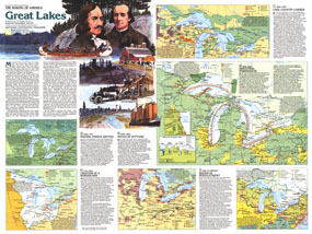
A maritime world in the heart of a continent, the Great Lakes have a long history of trade, immigration, agriculture, and industry. Published in July 1987, this map of the Great Lakes is half of a two-map set in the "Making of America" series. From the early days of the fur trade to Detroit's auto industry, this educational map provides a wealth of information on this fascinating region.

The 1987 Great Lakes map Side 2 features:
• An introduction to the history of the Great Lakes region
• A map of early French and British interaction with the native peoples including tribal groups, Indian villages, trade routes, forts, missions, and trails
• The Creation of a Borderland map detailing British and loyalist immigration, loyalist settlements, points of conflict, the 45 degree proposal, the 1782 compromise treaty line, and more
• A map and information about the region's logging industry including logger corridors, sawmill centers, pine forest areas, and more
• Maps of the region's industrial age showing automobile assembly sites, food processing plants, coal and limestone mining, pulp and paper mills, iron and steel centers, shipping, and more
• Information on the cultural diversity and immigration patterns of the region, land use, and recreational activities
• A profile of the Great Lakes showing their depths

Coverage Area: Ontario, Minnesota, Iowa, Wisconsin, Michigan, Pennsylvania, northern Illinois, northern Indiana, northern Ohio, northwestern New York

More Product Details

This map requires 7 business days to print and laminate prior to shipping.

Appearing in the July 1987 issue of the National Geographic Magazine, this Great Lakes map Side 2 has been reproduced from its original cartography in order to bring to life a beautiful poster previously only seen in National Geographic Magazine. This reproduction holds true to the high standards that National Geographic Maps are known for.

Perfect for home, office or classroom, this map also makes a great gift. Map collectors will surely want to add this map to their library.

The Paper version is printed on high quaility semi-gloss paper, perfect for framing.

The Laminated version uses 3mm laminate on both sides for durability, is easy to clean and markable.

From the National Geographic Classic Maps collection, this reproduction is just one of hundreds of titles available here. These maps are Printed on Demand. Sizes are approximate and may vary due to the nature of the trimming and laminating processes.
Shipping Conditions
Maps.com ships to Dometic US only

US FlagThis product can only be shipped to the Domestic U.S.A. (No APO's or PO Boxes)
TimeThis map requires 2 business days to print and laminate prior to shipping.