SHOP BY YEAR :: FOR OFFICE :: FOR CLASSROOM :: GIFT IDEAS :: CUSTOMER SERVICE

Boston To Washington Circa 1830 Map
Issue: July 1994
More Views
Enlarge Image
ZoomClick here to zoom!
Purchase Product :
Please select map format:
Laminated   
10" x 31" - $39.95
Laminated-w/Plastic Rails  (What are rails?)
10" x 31" - $51.95
Paper
10" x 31" - $29.95
Wallzilla Adhesive Format
10" x 31" - $59.95
Product Highlights
Boston To Washington Circa 1830 Map
Item#: X NGC 071994a

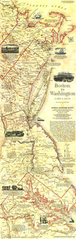
The "Boston to Washington, Circa 1830" map is a historical map based on plates drafted by Henry Schenk Tanner which covers the Atlantic Coast from Boston to Washington, D.C. Published in July 1994, this map features a variety of historical notes and illustrations. Half of a two-map set, it appeared with the "Boston to Washington, Megalopolis" map.

The 1994 Boston to Washington circa 1830 map features:
• Notes about 19th century commerce, transportation, canals, railroads, turnpikes, and westward migration
• Cities and towns
• Colleges, financial centers, forts, lighthouses, shipbuilding areas, and textile centers
• Canals, ferrys, railroads, and roads
• Mountain relief, rivers, and lakes
• Various small illustrations

Coverage Area: Rhode Island, Connecticut, Delaware, Massachusetts, New Jersey, Maryland, southern New York, southeastern New Hampshire, eastern Pennsylvania, northern Virginia

More Product Details

This map requires 7 business days to print and laminate prior to shipping.

Appearing in the July 1994 issue of the National Geographic Magazine, this Boston To Washington Circa 1830 map has been reproduced from its original cartography in order to bring to life a beautiful poster previously only seen in National Geographic Magazine. This reproduction holds true to the high standards that National Geographic Maps are known for.

Perfect for home, office or classroom, this map also makes a great gift. Map collectors will surely want to add this map to their library.

The Paper version is printed on high quaility semi-gloss paper, perfect for framing.

The Laminated version uses 3mm laminate on both sides for durability, is easy to clean and markable.

From the National Geographic Classic Maps collection, this reproduction is just one of hundreds of titles available here. These maps are Printed on Demand. Sizes are approximate and may vary due to the nature of the trimming and laminating processes.
Shipping Conditions
Maps.com ships to Dometic US only

US FlagThis product can only be shipped to the Domestic U.S.A. (No APO's or PO Boxes)
TimeThis map requires 2 business days to print and laminate prior to shipping.