SHOP BY YEAR :: FOR OFFICE :: FOR CLASSROOM :: GIFT IDEAS :: CUSTOMER SERVICE

United States Washington To Boston Map 1962
Issue: August 1962
More Views
Enlarge Image
ZoomClick here to zoom!
Purchase Product :
Please select map format:
Laminated   
25" x 19" - $19.95
Laminated-w/Plastic Rails  (What are rails?)
25" x 19" - $29.95
Paper
25" x 19" - $14.95
Wallzilla Adhesive Format
25" x 19" - $34.95
Product Highlights
United States Washington To Boston Map 1962
Item#: X NGC 081962

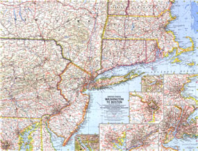
The "United States: Washington to Boston" map appeared in National Geographic with two articles, "The Old Boston Post Roads" and "The Post Road Today." Published in August 1962, this map includes a collection of detailed insets of Washington, Boston, Baltimore, Phildelphia, and New York.

The 1962 United States, Washington to Boston map features:
• Insets of Baltimore, Boston, New York, Philadelphia, and Washington
• Insets of Tourist Boston and Tourist Washington
• Capitals, cities, and towns
• Freeways, toll roads, roads, railroads, canals, and places with scheduled air service
• Intracoastal waterways and ferry routes
• Battle sites
• Mountains, rivers, and lakes

Coverage Area: Massachusetts, Rhode Island, Connecticut, New Jersey, northern Delaware, eastern Philadelphia, northern Maryland, central and southern New York, southern Vermont, southern New Hampshire

More Product Details

This map requires 7 business days to print and laminate prior to shipping.

Appearing in the August 1962 issue of the National Geographic Magazine, this United States Washington To Boston map has been reproduced from its original cartography in order to bring to life a beautiful poster previously only seen in National Geographic Magazine. This reproduction holds true to the high standards that National Geographic Maps are known for.

Perfect for home, office or classroom, this map also makes a great gift. Map collectors will surely want to add this map to their library.

The Paper version is printed on high quaility semi-gloss paper, perfect for framing.

The Laminated version uses 3mm laminate on both sides for durability, is easy to clean and markable.

From the National Geographic Classic Maps collection, this reproduction is just one of hundreds of titles available here. These maps are Printed on Demand. Sizes are approximate and may vary due to the nature of the trimming and laminating processes.
Shipping Conditions
Maps.com ships to Dometic US only

US FlagThis product can only be shipped to the Domestic U.S.A. (No APO's or PO Boxes)
TimeThis map requires 2 business days to print and laminate prior to shipping.