SHOP BY YEAR :: FOR OFFICE :: FOR CLASSROOM :: GIFT IDEAS :: CUSTOMER SERVICE

South Central States Map 1974
Issue: October 1974
More Views
Enlarge Image
ZoomClick here to zoom!
Purchase Product :
Please select map format:
Laminated   
35" x 23" - $39.95
Laminated-w/Plastic Rails  (What are rails?)
35" x 23" - $51.95
Paper
35" x 23" - $29.95
Wallzilla Adhesive Format
35" x 23" - $59.95
Product Highlights
South Central States Map 1974
Item#: X NGC 101974a

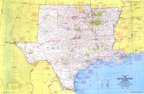
From cattle roundups and Indian cultural centers on the plains to Cajun bayous and Mardi Gras on the Mississippi delta, the South Central States are surprisingly diverse in their geographical features and their peoples. Published in October 1974, this map is half of a two-piece set in the "Close-Up: U.S.A." series. Its companion travel poster is entitled "Arkansas, Oklahoma, Louisiana, Texas: Rich Land of the Southern Frontier."

The 1974 South Central States map features:
• Sites and events noted in many tourist destinations as well as historical and geographical notes
• National parks, state parks, wildlife refuges, national forests and grasslands, Indian reservations, and more
• Wild or scenic rivers, intracoastal waterways, and historical and recreational trails
• Capitals, cities, and towns
• Interstate highways, other roads, passenger railroads, canals, and airports
• Subtle mountain relief, rivers, lakes, and swamps

Coverage Area: Texas, Oklahoma, Arkansas, Louisiana

More Product Details

This map requires 7 business days to print and laminate prior to shipping.

Appearing in the October 1974 issue of the National Geographic Magazine, this South Central States map has been reproduced from its original cartography in order to bring to life a beautiful poster previously only seen in National Geographic Magazine. This reproduction holds true to the high standards that National Geographic Maps are known for.

Perfect for home, office or classroom, this map also makes a great gift. Map collectors will surely want to add this map to their library.

The Paper version is printed on high quaility semi-gloss paper, perfect for framing.

The Laminated version uses 3mm laminate on both sides for durability, is easy to clean and markable.

From the National Geographic Classic Maps collection, this reproduction is just one of hundreds of titles available here. These maps are Printed on Demand. Sizes are approximate and may vary due to the nature of the trimming and laminating processes.
Shipping Conditions
Maps.com ships to Dometic US only

US FlagThis product can only be shipped to the Domestic U.S.A. (No APO's or PO Boxes)
TimeThis map requires 2 business days to print and laminate prior to shipping.