 |
|
|
|
|
Coast Of Northwest America Map 1899
Issue: November 1899
|
|
|
|
|
|
|
| Product Highlights |
| Coast Of Northwest America Map 1899 |
| Item#: X NGC 111899a |
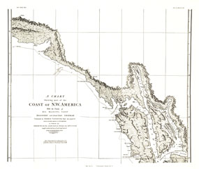
"A Chart Showing Part of the Coast of NW America (Vancouver's Chart, No. 1)" shows half of a chart of the coast of the Alaskan Panhandle and British Columbia including the Prince of Wales Archipelago, New Cornwall, and the Duke of Clarence's Strait. An antique black and white map perfect for framing, this map was published in November 1899 as half of a two-map set with the article "The Alaskan Boundary." The 1899 "A Chart Shewing Part of the Coast of NW America" map features:
• The tracks of His Majesty's sloop Discovery
• Intricate relief work
• Place names including islands, capes, points, straits, and more
Coverage Area: A section of Vancouver
|
|
 |
More Product Details
This map requires 7 business days to print and laminate prior to shipping.
Appearing in the November 1899 issue of the National Geographic Magazine, this Chart Showing Part Of The Coast Of Northwestern America map has been reproduced from its original cartography in order to bring to life a beautiful poster previously only seen in National Geographic Magazine. This reproduction holds true to the high standards that National Geographic Maps are known for.
Perfect for home, office or classroom, this map also makes a great gift. Map collectors will surely want to add this map to their library.
The Paper version is printed on high quaility semi-gloss paper, perfect for framing.
The Laminated version uses 3mm laminate on both sides for durability, is easy to clean and markable.
From the National Geographic Classic Maps collection, this reproduction is just one of hundreds of titles available here. These maps are Printed on Demand. Sizes are approximate and may vary due to the nature of the trimming and laminating processes.
|
|
Shipping Conditions
Maps.com ships to Dometic US only
 | This product can only be shipped to the Domestic U.S.A. (No APO's or PO Boxes) |  | This map requires 2 business days to print and laminate prior to shipping. |
|
|
|
|


 Click here to zoom!