 |
|
|
|
|
Africa, Its Political Development Map 1980
Issue: February 1980
|
|
|
|
|
|
|
| Product Highlights |
| Africa, Its Political Development Map 1980 |
| Item#: X NGC 021980b |
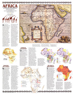
Anchored by a map originally crafted on canvas by Flemish cartographer Ortelius in the year 1750, this series of maps and explanations provides an astounding yet succinct overview of the political development of Africa. The "Africa, Its Political Development" map features:
• A map of Africa, first drawn in 1750
• A map showing known development from 1450 B.C to 1800 A.D
• A map showing the routes taken by James Bruce, David Livingstone, Henry Stanley, and many other European explorers
• Two maps shopwing the countries and borders of Africa in 1914 and 1939
• A map with the boundaries and years in which African countries gained their independence
• National Geographic explanations of each map and era-a political science lesson in itself
Coverage Area: Africa
|
|
 |
More Product Details
This map requires 7 business days to print and laminate prior to shipping.
Appearing in the February 1980 issue of the National Geographic Magazine, this Africa, Its Political Development map has been reproduced from its original cartography in order to bring to life a beautiful poster previously only seen in National Geographic Magazine. This reproduction holds true to the high standards that National Geographic Maps are known for.
Perfect for home, office or classroom, this map also makes a great gift. Map collectors will surely want to add this map to their library.
The Paper version is printed on high quaility semi-gloss paper, perfect for framing.
The Laminated version uses 3mm laminate on both sides for durability, is easy to clean and markable.
From the National Geographic Classic Maps collection, this reproduction is just one of hundreds of titles available here. These maps are Printed on Demand. Sizes are approximate and may vary due to the nature of the trimming and laminating processes.
|
|
Shipping Conditions
Maps.com ships to Dometic US only
 | This product can only be shipped to the Domestic U.S.A. (No APO's or PO Boxes) |  | This map requires 2 business days to print and laminate prior to shipping. |
|
|
|
|


 Click here to zoom!