 |
|
|
|
|
Northern Africa Map 1954
Issue: December 1954
|
|
|
|
|
|
|
| Product Highlights |
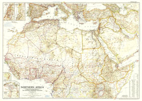
| Northern Africa Map 1954 |
| Item#: X NGC 121954 |
The article "Safari from Congo to Cairo" accompanied this map in the December 1954 issue of National Geographic. This map features political adminstration in northern Africa, as well as notes about changes in the middle east including the partitioning of Palestine. The 1954 Northern Africa map features:
• Inset maps of the eastern Mediterranean, Nile Delta and Suez Canal, and the Great Rift Valley
• Political administration in Northern Africa
• Capitals, cities, and towns
• Geographical features including mountains, rivers, lakes, volcanic debris, water holes, and areas below sea level
• Railways, roads, routes, canals, and airports
• Oil fields and pipelines
• Geographical equivalents
Coverage Area: Northern Africa
|
|
 |
More Product Details
This map requires 7 business days to print and laminate prior to shipping.
Appearing in the December 1954 issue of the National Geographic Magazine, this Northern Africa map has been reproduced from its original cartography in order to bring to life a beautiful poster previously only seen in National Geographic Magazine. This reproduction holds true to the high standards that National Geographic Maps are known for.
Perfect for home, office or classroom, this map also makes a great gift. Map collectors will surely want to add this map to their library.
The Paper version is printed on high quaility semi-gloss paper, perfect for framing.
The Laminated version uses 3mm laminate on both sides for durability, is easy to clean and markable.
From the National Geographic Classic Maps collection, this reproduction is just one of hundreds of titles available here. These maps are Printed on Demand. Sizes are approximate and may vary due to the nature of the trimming and laminating processes.
|
|
Shipping Conditions
Maps.com ships to Dometic US only
 | This product can only be shipped to the Domestic U.S.A. (No APO's or PO Boxes) |  | This map requires 2 business days to print and laminate prior to shipping. |
|
|
|
|


 Click here to zoom!