SHOP BY YEAR :: FOR OFFICE :: FOR CLASSROOM :: GIFT IDEAS :: CUSTOMER SERVICE

Africa Map 1990
Issue: December 1990
More Views
Enlarge Image
ZoomClick here to zoom!
Purchase Product :
Please select map format:
Laminated   
22" x 28.5" - $39.95
Laminated-w/Plastic Rails  (What are rails?)
22" x 28.5" - $51.95
Paper
22" x 28.5" - $29.95
Wallzilla Adhesive Format
22" x 28.5" - $59.95
Product Highlights
Africa Map 1990
Item#: X NGC 121990a

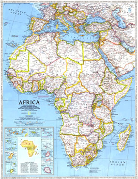
Discover the ever-changing continent of Africa with this vibrant, detailed map published in December of 1990. Printed as a companion to the "Africa Threatened" map and three articles on Africa including "A Gathering of Waters and Wildlife," this map brilliantly illustrates the extraordinary continent as only National Geographic can.

The 1990 Africa map features:
• Detailed insets of the Canary Islands, the Madeira Islands, Comoros, Seychelles, Mauritius, Rodrigues, Reunion, Sao Tome and Principe, Bioko, and the Cape Verde Islands
• Inset of Climate and Terrain
• Thousands of place names including country capitals, cities, and towns
• Rivers and lakes, including intermittant lakes and dry salt lakes
• Railroads, roads, scheduled air service, and canals
• Oil pipelines, oil fields, and ruins
• Soil details such as sand and volcanic debris, as well as elevations, depth curves, and soundings

Coverage Area: Africa, Madagascar, Southern Europe, Turkey, Syria, Iraq, Jordan, Saudi Arabia, Yemen

More Product Details

This map requires 7 business days to print and laminate prior to shipping.

Appearing in the December 1990 issue of the National Geographic Magazine, this Africa map has been reproduced from its original cartography in order to bring to life a beautiful poster previously only seen in National Geographic Magazine. This reproduction holds true to the high standards that National Geographic Maps are known for.

Perfect for home, office or classroom, this map also makes a great gift. Map collectors will surely want to add this map to their library.

The Paper version is printed on high quaility semi-gloss paper, perfect for framing.

The Laminated version uses 3mm laminate on both sides for durability, is easy to clean and markable.

From the National Geographic Classic Maps collection, this reproduction is just one of hundreds of titles available here. These maps are Printed on Demand. Sizes are approximate and may vary due to the nature of the trimming and laminating processes.
Shipping Conditions
Maps.com ships to Dometic US only

US FlagThis product can only be shipped to the Domestic U.S.A. (No APO's or PO Boxes)
TimeThis map requires 2 business days to print and laminate prior to shipping.