SHOP BY YEAR :: FOR OFFICE :: FOR CLASSROOM :: GIFT IDEAS :: CUSTOMER SERVICE

Philippines Military Telegraph Lines Map 1902
Issue: January 1902
More Views
Enlarge Image
ZoomClick here to zoom!
Purchase Product :
Please select map format:
Laminated   
40" x 33.5" - $59.95
Laminated-w/Plastic Rails  (What are rails?)
40" x 33.5" - $76.95
Paper
40" x 33.5" - $49.95
Wallzilla Adhesive Format
40" x 33.5" - $89.95
Product Highlights
Philippines Military Telegraph Lines Map 1902
Item#: X NGC 011902a

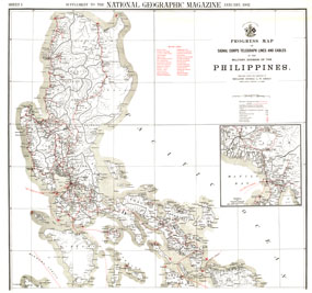
This map was produced in astonishing detail as a supplement to the January, 1902 National Geographic Magazine, and accompanies the southern Philippines map. Just four years earlier, the United States purchased the rights to the territory from Spain for ,000,000, and this beautiful map shows the entire group of islands, anlong with a detailed inset of the Manila Bay area. Anyone interested in history or the Far East will find this map to be an excellent addition to your map collection.

The 1902 Philippines Military Telegraph Lines map features:
• The northern Philippine Islands and borders for each province
• Military cable lines and telegraph lines
• Hundreds of cities and towns
• A detailed inset of Manila Bay
• Commercial and military telegraph stations, and telephone stations
• Ports, lighthouses, and post offices

Coverage Area: The northern Philippine Islands, Manila Bay inset

More Product Details

This map requires 7 business days to print and laminate prior to shipping.

Appearing in the January 1902 issue of the National Geographic Magazine, this Philippines Military Telegraph Lines map has been reproduced from its original cartography in order to bring to life a beautiful poster previously only seen in National Geographic Magazine. This reproduction holds true to the high standards that National Geographic Maps are known for.

The Paper version is printed on high quaility semi-gloss paper, perfect for framing.

The Laminated version uses 3mm laminate on both sides for durability, is easy to clean and markable.

From the National Geographic Classic Maps collection, this reproduction is just one of hundreds of titles available here. These maps are Printed on Demand. Sizes are approximate and may vary due to the nature of the trimming and laminating processes.
Shipping Conditions
Maps.com ships to Dometic US only

US FlagThis product can only be shipped to the Domestic U.S.A. (No APO's or PO Boxes)
TimeThis map requires 2 business days to print and laminate prior to shipping.