SHOP BY YEAR :: FOR OFFICE :: FOR CLASSROOM :: GIFT IDEAS :: CUSTOMER SERVICE

Eastern Soviet Union Map 1967
Issue: March 1967
More Views
Enlarge Image
ZoomClick here to zoom!
Purchase Product :
Please select map format:
Laminated   
25" x 19" - $19.95
Laminated-w/Plastic Rails  (What are rails?)
25" x 19" - $29.95
Paper
25" x 19" - $14.95
Wallzilla Adhesive Format
25" x 19" - $34.95
Product Highlights
Eastern Soviet Union Map 1967
Item#: X NGC 031967

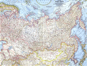
This map of the eastern portion of the Soviet Union was published in March 1967 with the article "Siberia: Russias Frozen Frontier." It features many physical and political details including the countrys boundaries in 1938 and the northern limits of wooded country.

The 1967 Eastern Soviet Union map features:
• 1938 Soviet boundaries, and administrative subdivisions of the Russian Soviet Federated Socialist Republic outlined
• Thousands of place names including capitals, cities, and towns
• Ocean bathmetry and geographical features including mountains, lakes, rivers, glaciers, tundra, and more
• Northern limits of wooded country
• Railroads, roads, canals, and places with scheduled air service
• Oil fields and pipelines
• Ruins and Chinese walls

Coverage Area: Eastern Soviet Union, Sweden, Norway, Finland, Mongolian Republic, northern China, Japan, Korea

More Product Details

This map requires 7 business days to print and laminate prior to shipping.

Appearing in the March 1967 issue of the National Geographic Magazine, this Eastern Soviet Union map has been reproduced from its original cartography in order to bring to life a beautiful poster previously only seen in National Geographic Magazine. This reproduction holds true to the high standards that National Geographic Maps are known for.

Perfect for home, office or classroom, this map also makes a great gift. Map collectors will surely want to add this map to their library.

The Paper version is printed on high quaility semi-gloss paper, perfect for framing.

The Laminated version uses 3mm laminate on both sides for durability, is easy to clean and markable.

From the National Geographic Classic Maps collection, this reproduction is just one of hundreds of titles available here. These maps are Printed on Demand. Sizes are approximate and may vary due to the nature of the trimming and laminating processes.
Shipping Conditions
Maps.com ships to Dometic US only

US FlagThis product can only be shipped to the Domestic U.S.A. (No APO's or PO Boxes)
TimeThis map requires 2 business days to print and laminate prior to shipping.