|
|
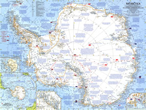
Antarctica Map 1962
Issue: February 1963

|
|
|
|
|
|
|
| Product Highlights |
| Antarctica Map 1962 |
| Item#: X NGC 021963 |
Explore the harsh, yet magnificent terrain of Antarctica in this finely detailed and educational map. Filled with information on the geography as well as historical facts about the exploration of the continent, this map was published in February 1963 with an article entitled "New Era in the Loneliest Continent." The 1963 Antarctica map features:
• An abundance of information about the geography and history of Antarctic exploration
• An ice terminology key
• Detailed insets of the Queen Maud Range and McMurdo Sound
• Inset showing relation of Antarctica to surrounding continents
• Subglacial Antarctic inset
• Flags mark the nationality of the Antarctic bases and expedition routes are clearly defined
• Glaciers, ice shelfs, and mountain ranges are clearly illustrated
Coverage Area: Antarctica
|
|
More Product Details
This map requires 7 business days to print and laminate prior to shipping.
Appearing in the February 1963 issue of the National Geographic Magazine, this Antarctica map has been reproduced from its original cartography in order to bring to life a beautiful poster previously only seen in National Geographic Magazine. This reproduction holds true to the high standards that National Geographic Maps are known for.
Perfect for home, office or classroom, this map also makes a great gift. Map collectors will surely want to add this map to their library.
The Paper version is printed on high quaility semi-gloss paper, perfect for framing.
The Laminated version uses 3mm laminate on both sides for durability, is easy to clean and markable.
From the National Geographic Classic Maps collection, this reproduction is just one of hundreds of titles available here. These maps are Printed on Demand. Sizes are approximate and may vary due to the nature of the trimming and laminating processes.
|
|
Shipping Conditions
Maps.com ships to Dometic US only
 | This product can only be shipped to the Domestic U.S.A. (No APO's or PO Boxes) |  | This map requires 2 business days to print and laminate prior to shipping. |
|


 Click here to zoom!