SHOP BY YEAR :: FOR OFFICE :: FOR CLASSROOM :: GIFT IDEAS :: CUSTOMER SERVICE

North Pole Regions Map 1907
Issue: July 1907
More Views
Enlarge Image
ZoomClick here to zoom!
Purchase Product :
Please select map format:
Laminated   
19" x 19" - $19.95
Laminated-w/Plastic Rails  (What are rails?)
19" x 19" - $29.95
Paper
19" x 19" - $14.95
Wallzilla Adhesive Format
19" x 19" - $34.95
Product Highlights
North Pole Regions Map 1907
Item#: X NGC 071907

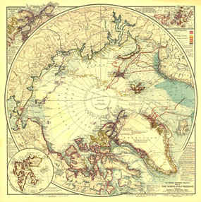
A true work of art, this map of the North Pole regions is as beautiful as it is fascinating. Published with five articles on the Arctic including "Arctic Expeditions Commanded by Americans," this one of a kind map is loaded with information about Arctic exploration and is perfect for framing.

The 1907 North Pole Regions map features:
• Detailed inset of the Smith Sound Region including noted explorers of the American Smith Sound route and Pearys explorations
• Inset of Spitzbergen
• Colored explorers routes
• Historical details of various expeditions
• Coastlines are colored to denote the nations which explored them
• Mountains, rivers, seas, bays, islands, and towns
• Telegraph lines, railroads, steamship routes, and winter harbors

Coverage Area: North Pole, Alaska, Greenland, Spitzbergen, Franz Josef Land, northern Canada, northern Siberia, Sweden, Norway, and Finland

More Product Details

This map requires 7 business days to print and laminate prior to shipping.

Appearing in the July 1907 issue of the National Geographic Magazine, this North Pole Regions map has been reproduced from its original cartography in order to bring to life a beautiful poster previously only seen in National Geographic Magazine. This reproduction holds true to the high standards that National Geographic Maps are known for.

Perfect for home, office or classroom, this map also makes a great gift. Map collectors will surely want to add this map to their library.

The Paper version is printed on high quaility semi-gloss paper, perfect for framing.

The Laminated version uses 3mm laminate on both sides for durability, is easy to clean and markable.

From the National Geographic Classic Maps collection, this reproduction is just one of hundreds of titles available here. These maps are Printed on Demand. Sizes are approximate and may vary due to the nature of the trimming and laminating processes.
Shipping Conditions
Maps.com ships to Dometic US only

US FlagThis product can only be shipped to the Domestic U.S.A. (No APO's or PO Boxes)
TimeThis map requires 2 business days to print and laminate prior to shipping.