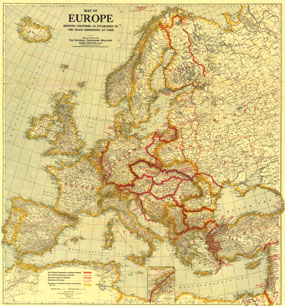
A must-have for history buffs, this map depicts Europe as established by the Peace Conference of Paris. New political borders, borders as they existed before World War I, international territories, and territories subject to plebiscite are detailed on this map which accompanied three articles on Europe in the February 1921 issue of National Geographic including "Czechoslovakia, Key-Land to Central Europe." The 1921 Europe map features:
• New political boundaries as definitely decided and undecided
• Territories subject to plebiscite and international territories
• Boundaries of countries as they existed before the war
• An inset of the Dardanelles
• Thousands of place names including capitals, cities, and towns
• Railroads and ship canals
• Mountains, rivers, and lakes
Coverage Area: Europe, western Russia
|


 Click here to zoom!
