 |
|
|
|
|
Historical Italy Map 1995
Issue: February 1995
|
|
|
|
|
|
|
| Product Highlights |
| Historical Italy Map 1995 |
| Item#: X NGC 021995b |
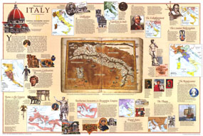
Half of a two-map set, this historical map of Italy appeared in the February 1995 issue of National Geographic with a stunning physical and political map of the country and an article on Venice. Filled with historical information and illustrations, this map boasts eleven inset maps detailing key periods. The 1995 Historical Italy map features:
• Map of the Roman Empire at its greatest extent and an overview of the period
• Maps and information on the Etruscan civilization, barbarian invasions and the Byzantine empire, and the Papal states
• An overview and map of the Plague years, showing the route of the deadly epidemic
• Inset maps and information on the Renaissance, the Counter-Reformation, and the Enlightenment
• Maps and overviews of Napoleon in Italy, and the Unification
• An illustration of a map of Italy published in 1486
• Illustrations and information about historical figures and artifacts
Coverage Area: Italy
|
|
 |
More Product Details
This map requires 7 business days to print and laminate prior to shipping.
Appearing in the February 1995 issue of the National Geographic Magazine, this Historical Italy map has been reproduced from its original cartography in order to bring to life a beautiful poster previously only seen in National Geographic Magazine. This reproduction holds true to the high standards that National Geographic Maps are known for.
Perfect for home, office or classroom, this map also makes a great gift. Map collectors will surely want to add this map to their library.
The Paper version is printed on high quaility semi-gloss paper, perfect for framing.
The Laminated version uses 3mm laminate on both sides for durability, is easy to clean and markable.
From the National Geographic Classic Maps collection, this reproduction is just one of hundreds of titles available here. These maps are Printed on Demand. Sizes are approximate and may vary due to the nature of the trimming and laminating processes.
|
|
Shipping Conditions
Maps.com ships to Dometic US only
 | This product can only be shipped to the Domestic U.S.A. (No APO's or PO Boxes) |  | This map requires 2 business days to print and laminate prior to shipping. |
|
|
|
|


 Click here to zoom!