SHOP BY YEAR :: FOR OFFICE :: FOR CLASSROOM :: GIFT IDEAS :: CUSTOMER SERVICE

British Isles Map 1949
Issue: April 1949
More Views
Enlarge Image
ZoomClick here to zoom!
Purchase Product :
Please select map format:
Laminated   
26" x 32" - $39.95
Laminated-w/Plastic Rails  (What are rails?)
26" x 32" - $51.95
Paper
26" x 32" - $29.95
Wallzilla Adhesive Format
26" x 32" - $59.95
Product Highlights
British Isles Map 1949
Item#: X NGC 041949

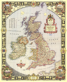
With its elaborate, illustrated border and stylish legend, this map of the British Isles was made for framing. Published in April 1949, it is both a work of art as well as an informative map, containing an abundance of places of interest including cathedrals, ruins, battlefields, and more.

The 1949 British Isles map features:
• A list of counties with their abbreviations
• Elaborate border with illustrations of notable historical figures, cities, famous sites, and more
• County seats
• Roads, railways, and canals
• Castles, ruins, cathedrals, famous churches, battle sites, lighthouses, and other places of interest
• Elevations

Coverage Area: British Isles

More Product Details

This map requires 7 business days to print and laminate prior to shipping.

Appearing in the April 1949 issue of the National Geographic Magazine, this British Isles map has been reproduced from its original cartography in order to bring to life a beautiful poster previously only seen in National Geographic Magazine. This reproduction holds true to the high standards that National Geographic Maps are known for.

Perfect for home, office or classroom, this map also makes a great gift. Map collectors will surely want to add this map to their library.

The Paper version is printed on high quaility semi-gloss paper, perfect for framing.

The Laminated version uses 3mm laminate on both sides for durability, is easy to clean and markable.

From the National Geographic Classic Maps collection, this reproduction is just one of hundreds of titles available here. These maps are Printed on Demand. Sizes are approximate and may vary due to the nature of the trimming and laminating processes.
Shipping Conditions
Maps.com ships to Dometic US only

US FlagThis product can only be shipped to the Domestic U.S.A. (No APO's or PO Boxes)
TimeThis map requires 2 business days to print and laminate prior to shipping.