 |
|
|
|
|
Historic Ireland Map 1981
Issue: April 1981
|
|
|
|
|
|
|
| Product Highlights |
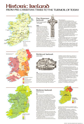
| Historic Ireland Map 1981 |
| Item#: X NGC 041981b |
This educational map of Historic Ireland was published in April 1981 with three articles on Ireland and an additional map entitled "Ireland and Northern Ireland: A Visitor's Guide." These maps provide a wonderful overview of the island's tumultuous and colorful history. The 1981 Historic Ireland map from Pre-Christian Times to the Turmoil of Today features:
• Map of pre-Norman Ireland showing historic sites including abbeys, churches, high crosses, monastic sites, and round towers
• Map of Medieval Ireland showing prominent Irish families at the end of the 16th century, plantations, settlements, and more
• Map of population changes by county from 1841-1851
• Map of the percentage of Catholics by county in 1926
• Historical overviews of three eras of Irish history: Pre-Norman, Medieval, and Modern Ireland
Coverage Area: Ireland, Northern Ireland
|
|
 |
More Product Details
This map requires 7 business days to print and laminate prior to shipping.
Appearing in the April 1981 issue of the National Geographic Magazine, this Historic Ireland map has been reproduced from its original cartography in order to bring to life a beautiful poster previously only seen in National Geographic Magazine. This reproduction holds true to the high standards that National Geographic Maps are known for.
Perfect for home, office or classroom, this map also makes a great gift. Map collectors will surely want to add this map to their library.
The Paper version is printed on high quaility semi-gloss paper, perfect for framing.
The Laminated version uses 3mm laminate on both sides for durability, is easy to clean and markable.
From the National Geographic Classic Maps collection, this reproduction is just one of hundreds of titles available here. These maps are Printed on Demand. Sizes are approximate and may vary due to the nature of the trimming and laminating processes.
|
|
Shipping Conditions
Maps.com ships to Dometic US only
 | This product can only be shipped to the Domestic U.S.A. (No APO's or PO Boxes) |  | This map requires 2 business days to print and laminate prior to shipping. |
|
|
|
|


 Click here to zoom!