|
|
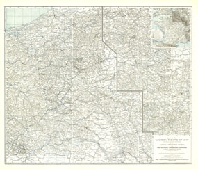
The Western Theatre Of War Map 1918
Issue: May 1918

|
|
|
|
|
|
|
| Product Highlights |
| The Western Theatre Of War Map 1918 |
| Item#: X NGC 051918 |
Printed in May 1918 a short time before the end of World War I, this map shows the western theatre of war in France and Belgium. Details of battle lines make this map a unique and compelling historical piece perfect for collectors. The 1918 Map of the Western Theater of War features:
• Inset map showing the relation of the Western Theater of War to the surrounding region and the connection of the two sections of the main map
• War details including the line of greatest German advance in 1914 and the battle line before the spring drive of 1918
• An abundance of place names including cities and towns
• Rivers clearly shown in blue
• Railroads and tram lines
Coverage Area: France, Belgium, western Germany
|
|
More Product Details
This map requires 7 business days to print and laminate prior to shipping.
Appearing in the May 1918 issue of the National Geographic Magazine, this Map Of The Western Theatre Of War map has been reproduced from its original cartography in order to bring to life a beautiful poster previously only seen in National Geographic Magazine. This reproduction holds true to the high standards that National Geographic Maps are known for.
Perfect for home, office or classroom, this map also makes a great gift. Map collectors will surely want to add this map to their library.
The Paper version is printed on high quaility semi-gloss paper, perfect for framing.
The Laminated version uses 3mm laminate on both sides for durability, is easy to clean and markable.
From the National Geographic Classic Maps collection, this reproduction is just one of hundreds of titles available here. These maps are Printed on Demand. Sizes are approximate and may vary due to the nature of the trimming and laminating processes.
|
|
Shipping Conditions
Maps.com ships to Dometic US only
 | This product can only be shipped to the Domestic U.S.A. (No APO's or PO Boxes) |  | This map requires 2 business days to print and laminate prior to shipping. |
|


 Click here to zoom!