SHOP BY YEAR :: FOR OFFICE :: FOR CLASSROOM :: GIFT IDEAS :: CUSTOMER SERVICE

Europe Map 1962
Issue: June 1962
More Views
Enlarge Image
ZoomClick here to zoom!
Purchase Product :
Please select map format:
Laminated   
25" x 19" - $19.95
Laminated-w/Plastic Rails  (What are rails?)
25" x 19" - $29.95
Paper
25" x 19" - $14.95
Wallzilla Adhesive Format
25" x 19" - $34.95
Product Highlights
Europe Map 1962
Item#: X NGC 061962

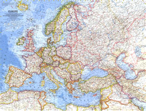
This marvelously detailed map of Europe was published in June 1962 with the article "In the Crusaders Footsteps." A brilliant example of the cartographic excellence National Geographic is known for, this map is provides a Cold War snapshot of Europe including borders of Germany, Poland, and the Soviet Union as they existed in 1938.

The 1962 Europe map features:
• Thousands of place names including capitals, cities, and towns
• Mountains, rivers, lakes, intermittent lakes, dry salt lakes, tundra, glaciers, lava, deserts, and areas below sea level
• Ocean bathymetry and warm and cold currents
• Railroads (both existing and under construction), roads, places with scheduled air service, and canals
• Colorful country borders including the 1938 boundaries of Germany, Poland and the Soviet Union
• Passes and ruins
• Oil fields, oil pipelines, and pumping stations

Coverage Area: Europe, western USSR, Turkey, Syria, Jordan, Iraq

More Product Details

This map requires 7 business days to print and laminate prior to shipping.

Appearing in the June 1962 issue of the National Geographic Magazine, this Europe map has been reproduced from its original cartography in order to bring to life a beautiful poster previously only seen in National Geographic Magazine. This reproduction holds true to the high standards that National Geographic Maps are known for.

Perfect for home, office or classroom, this map also makes a great gift. Map collectors will surely want to add this map to their library.

The Paper version is printed on high quaility semi-gloss paper, perfect for framing.

The Laminated version uses 3mm laminate on both sides for durability, is easy to clean and markable.

From the National Geographic Classic Maps collection, this reproduction is just one of hundreds of titles available here. These maps are Printed on Demand. Sizes are approximate and may vary due to the nature of the trimming and laminating processes.
Shipping Conditions
Maps.com ships to Dometic US only

US FlagThis product can only be shipped to the Domestic U.S.A. (No APO's or PO Boxes)
TimeThis map requires 2 business days to print and laminate prior to shipping.