SHOP BY YEAR :: FOR OFFICE :: FOR CLASSROOM :: GIFT IDEAS :: CUSTOMER SERVICE

Europe Map 1969
Issue: June 1969
More Views
Enlarge Image
ZoomClick here to zoom!
Purchase Product :
Please select map format:
Laminated   
26.5" x 30" - $39.95
Laminated-w/Plastic Rails  (What are rails?)
26.5" x 30" - $51.95
Paper
26.5" x 30" - $29.95
Wallzilla Adhesive Format
26.5" x 30" - $59.95
Product Highlights
Europe Map 1969
Item#: X NGC 061969a

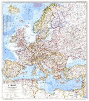
In comparison to earlier maps of Europe, this map is the first to show the network of superhighways criss-crossing the continent as European transportation surged. Published in June 1969, it accompanied an article entitled "Europe, A Restless Continent Remapped."

The 1969 Europe map features:
• Historical notes about relevant political changes in Europe and the Middle East
• Thousands of place names including capitals, cities, and towns
• Superhighways and railroads (both existing and under construction), roads, the Berlin corridor, tracks, principal airports, and canals
• Mountains, rivers, lakes, intermittent lakes, dry lakes, swamps, glaciers, deserts, water holes, and areas below sea level
• Ocean bathymetry
• Oil fields and oil pipelines
• Geographical equivalents and abbreviations

Coverage Area: Europe, western USSR, western Turkey, Israel, Lebanon

More Product Details

This map requires 7 business days to print and laminate prior to shipping.

Appearing in the June 1969 issue of the National Geographic Magazine, this Europe map has been reproduced from its original cartography in order to bring to life a beautiful poster previously only seen in National Geographic Magazine. This reproduction holds true to the high standards that National Geographic Maps are known for.

Perfect for home, office or classroom, this map also makes a great gift. Map collectors will surely want to add this map to their library.

The Paper version is printed on high quaility semi-gloss paper, perfect for framing.

The Laminated version uses 3mm laminate on both sides for durability, is easy to clean and markable.

From the National Geographic Classic Maps collection, this reproduction is just one of hundreds of titles available here. These maps are Printed on Demand. Sizes are approximate and may vary due to the nature of the trimming and laminating processes.
Shipping Conditions
Maps.com ships to Dometic US only

US FlagThis product can only be shipped to the Domestic U.S.A. (No APO's or PO Boxes)
TimeThis map requires 2 business days to print and laminate prior to shipping.