 |
|
|
|
|
Central Europe Map 1951
Issue: September 1951
|
|
|
|
|
|
|
| Product Highlights |
| Central Europe Map 1951 |
| Item#: X NGC 091951a |
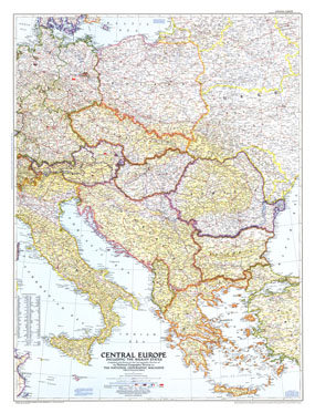
This map of Central Europe and the Balkan States captures Europe still in the recovery stages after World War II. Published in September 1951, it includes American, British, French, and Russian occupation zones and the newly drawn boundaries of Russia and Poland. The 1951 Central Europe map features:
• Flags denoting American, British, French, and Russian occupational zones in Germany and Austria, World War II
• Russian and Polish boundaries according to treaties and claims as of July 1, 1951
• Capitals, cities, and towns
• Mountains, passes, rivers, and lakes
• Principal railways, highways, Autobahn, canals, and principal airports
• Ruins
• Oil fields and pipelines
Coverage Area: Central Europe
|
|
 |
More Product Details
This map requires 7 business days to print and laminate prior to shipping.
Appearing in the September 1951 issue of the National Geographic Magazine, this Central Europe map has been reproduced from its original cartography in order to bring to life a beautiful poster previously only seen in National Geographic Magazine. This reproduction holds true to the high standards that National Geographic Maps are known for.
Perfect for home, office or classroom, this map also makes a great gift. Map collectors will surely want to add this map to their library.
The Paper version is printed on high quaility semi-gloss paper, perfect for framing.
The Laminated version uses 3mm laminate on both sides for durability, is easy to clean and markable.
From the National Geographic Classic Maps collection, this reproduction is just one of hundreds of titles available here. These maps are Printed on Demand. Sizes are approximate and may vary due to the nature of the trimming and laminating processes.
|
|
Shipping Conditions
Maps.com ships to Dometic US only
 | This product can only be shipped to the Domestic U.S.A. (No APO's or PO Boxes) |  | This map requires 2 business days to print and laminate prior to shipping. |
|
|
|
|


 Click here to zoom!