SHOP BY YEAR :: FOR OFFICE :: FOR CLASSROOM :: GIFT IDEAS :: CUSTOMER SERVICE

Western Soviet Union Map 1959
Issue: September 1959
More Views
Enlarge Image
ZoomClick here to zoom!
Purchase Product :
Please select map format:
Laminated   
19" x 25" - $19.95
Laminated-w/Plastic Rails  (What are rails?)
19" x 25" - $29.95
Paper
19" x 25" - $14.95
Wallzilla Adhesive Format
19" x 25" - $34.95
Product Highlights
Western Soviet Union Map 1959
Item#: X NGC 091959a

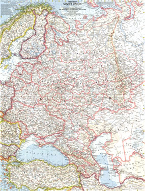
This Cold War era map of the Western Soviet Union appeared in National Geographic Magazine in September 1959 with two articles on the region. Three years prior, Soviet military force was used to suppress uprisings in Poland and Hungary. This era also saw the Soviets launch the first artificial satellite into orbit, beginning the space race with the United States.

The 1959 Western Soviet Union map features:
• National and Soviet Socialist Republic capitals, cities, and towns
• 1938 Soviet boundaries
• Railroads, roads, canals, and places with scheduled air service
• Ocean bathymetry
• Mountain relief, rivers, lakes, swamps, tundra, deserts, and areas below sea level
• Oil fields and pipelines
• Ruins

Coverage Area: Western Soviet Union, Finland, Turkey, northern Sweden, northern Norway, eastern Poland, eastern Romania, eastern Bulgaria

More Product Details

This map requires 7 business days to print and laminate prior to shipping.

Appearing in the September 1959 issue of the National Geographic Magazine, this Western Soviet Union map has been reproduced from its original cartography in order to bring to life a beautiful poster previously only seen in National Geographic Magazine. This reproduction holds true to the high standards that National Geographic Maps are known for.

Perfect for home, office or classroom, this map also makes a great gift. Map collectors will surely want to add this map to their library.

The Paper version is printed on high quaility semi-gloss paper, perfect for framing.

The Laminated version uses 3mm laminate on both sides for durability, is easy to clean and markable.

From the National Geographic Classic Maps collection, this reproduction is just one of hundreds of titles available here. These maps are Printed on Demand. Sizes are approximate and may vary due to the nature of the trimming and laminating processes.
Shipping Conditions
Maps.com ships to Dometic US only

US FlagThis product can only be shipped to the Domestic U.S.A. (No APO's or PO Boxes)
TimeThis map requires 2 business days to print and laminate prior to shipping.