SHOP BY YEAR :: FOR OFFICE :: FOR CLASSROOM :: GIFT IDEAS :: CUSTOMER SERVICE

Central Europe And The Mediterranean Map 1939
Issue: October 1939
More Views
Enlarge Image
ZoomClick here to zoom!
Purchase Product :
Please select map format:
Laminated   
37" x 27.5" - $59.95
Laminated-w/Plastic Rails  (What are rails?)
37" x 27.5" - $76.95
Paper
37" x 27.5" - $49.95
Wallzilla Adhesive Format
37" x 27.5" - $89.95
Product Highlights
Central Europe And The Mediterranean Map 1939
Item#: X NGC 101939

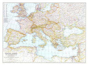
This map of Central Europe and the Mediterranean shows international boundaries as of September 1, 1939, before Germany invaded Poland. Published in October 1939, this map appeared with the article "War Clouds Over Danzig and Poland's Port." A unique historical map for collectors.

The 1939 Central Europe and the Mediterranean map features:
• Names of countries in English and the national language
• Thousands of place names including capitals of countries, other capitals, cities, and towns
• Mountain relief, rivers, lakes, glaciers, wadies, swamps, and areas below sea level
• Railways and canals
• Geographical equivalents

Coverage Area: Central Europe, western USSR, western Turkey, Mediterranean coasts of Asia and Africa

More Product Details

This map requires 7 business days to print and laminate prior to shipping.

Appearing in the October 1939 issue of the National Geographic Magazine, this Central Europe And The Mediterranean, 1939 map has been reproduced from its original cartography in order to bring to life a beautiful poster previously only seen in National Geographic Magazine. This reproduction holds true to the high standards that National Geographic Maps are known for.

Perfect for home, office or classroom, this map also makes a great gift. Map collectors will surely want to add this map to their library.

The Paper version is printed on high quaility semi-gloss paper, perfect for framing.

The Laminated version uses 3mm laminate on both sides for durability, is easy to clean and markable.

From the National Geographic Classic Maps collection, this reproduction is just one of hundreds of titles available here. These maps are Printed on Demand. Sizes are approximate and may vary due to the nature of the trimming and laminating processes.
Shipping Conditions
Maps.com ships to Dometic US only

US FlagThis product can only be shipped to the Domestic U.S.A. (No APO's or PO Boxes)
TimeThis map requires 2 business days to print and laminate prior to shipping.