 |
|
|
|
|
Medieval England Map 1979
Issue: October 1979
|
|
|
|
|
|
|
| Product Highlights |
| Medieval England Map 1979 |
| Item#: X NGC 101979b |
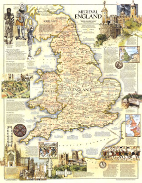
Perfect for framing, this map of Medieval England contains a wealth of historical information and sites as well as beautiful illustrations. Published is October 1979 with an additional map of the British Isles, this work makes a fine keepsake for those interested in this colorful period of English history. The 1979 Medieval England map features:
• An abundance of historical information about cities and other sites
• England in the 8th century and Henry II's empire, 1154-1189
• Illustrations of knights, cathedrals, the Tower of London, and more
• Information on the Battle of Hastings
• Towns, castles, great houses, palaces, early ruins, and battles
• Churches, cathedrals, abbeys, priories, and monastaries
• Roads built by Romans
Coverage Area: England, Wales
|
|
 |
More Product Details
This map requires 7 business days to print and laminate prior to shipping.
Appearing in the October 1979 issue of the National Geographic Magazine, this Medieval England map has been reproduced from its original cartography in order to bring to life a beautiful poster previously only seen in National Geographic Magazine. This reproduction holds true to the high standards that National Geographic Maps are known for.
Perfect for home, office or classroom, this map also makes a great gift. Map collectors will surely want to add this map to their library.
The Paper version is printed on high quaility semi-gloss paper, perfect for framing.
The Laminated version uses 3mm laminate on both sides for durability, is easy to clean and markable.
From the National Geographic Classic Maps collection, this reproduction is just one of hundreds of titles available here. These maps are Printed on Demand. Sizes are approximate and may vary due to the nature of the trimming and laminating processes.
|
|
Shipping Conditions
Maps.com ships to Dometic US only
 | This product can only be shipped to the Domestic U.S.A. (No APO's or PO Boxes) |  | This map requires 2 business days to print and laminate prior to shipping. |
|
|
|
|


 Click here to zoom!