 |
|
|
|
|
Historic Mediterranean, 800 BC to AD 1500 Map
Issue: December 1982
|
|
|
|
|
|
|
| Product Highlights |
| Historic Mediterranean, 800 BC to AD 1500 Map |
| Item#: X NGC 121982a |
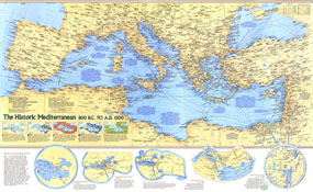
The Mediterranean region was home to many of the greatest civilizations in human history including the ancient Greeks and Romans. The Historic Mediterranean map contains a wealth of information about the history of the civilizations who inhabited the region from 800 BC to AD 1500 and the archeaological sites they left behind. Published in December 1982, this educational map accompanied three articles on the Mediterranean Sea and an outstanding map of the Mediterranean seafloor. The 1982 "The Historic Mediterranean, 800 BC to AD 1500" map features:
• Heart of an Expanding World which contains five maps of periods from Homer's world in 700 BC to the Hereford Map of 1290
• Five insets maps illustrating the Phoenician, Greek, Roman, Byzantine, and Islamic periods of history
• An abundance of historical notes and information on major cities, shipwrecks, submerged ruins, ancient ports, and more
• Sites coded to show the civilizations that occupied them
• Walls, ruins, submerged ruins, battle sites, shipwrecks, and sites of archaeological or historical importance
• Roman roads, passes, trade routes, and probable trade routes
• Sites where the identification or location are uncertain
Coverage Area: Southern Europe, Asia Minor, Mediterranean coast of North Africa
|
|
 |
More Product Details
This map requires 7 business days to print and laminate prior to shipping.
Appearing in the December 1982 issue of the National Geographic Magazine, this Historic Mediterranean, 800 BC To AD 1500 map has been reproduced from its original cartography in order to bring to life a beautiful poster previously only seen in National Geographic Magazine. This reproduction holds true to the high standards that National Geographic Maps are known for.
Perfect for home, office or classroom, this map also makes a great gift. Map collectors will surely want to add this map to their library.
The Paper version is printed on high quaility semi-gloss paper, perfect for framing.
The Laminated version uses 3mm laminate on both sides for durability, is easy to clean and markable.
From the National Geographic Classic Maps collection, this reproduction is just one of hundreds of titles available here. These maps are Printed on Demand. Sizes are approximate and may vary due to the nature of the trimming and laminating processes.
|
|
Shipping Conditions
Maps.com ships to Dometic US only
 | This product can only be shipped to the Domestic U.S.A. (No APO's or PO Boxes) |  | This map requires 2 business days to print and laminate prior to shipping. |
|
|
|
|


 Click here to zoom!