SHOP BY YEAR :: FOR OFFICE :: FOR CLASSROOM :: GIFT IDEAS :: CUSTOMER SERVICE

Lands Of The Bible Today Map 1967
Issue: December 1967
More Views
Enlarge Image
ZoomClick here to zoom!
Purchase Product :
Please select map format:
Laminated   
41" x 29" - $59.95
Laminated-w/Plastic Rails  (What are rails?)
41" x 29" - $76.95
Paper
41" x 29" - $49.95
Wallzilla Adhesive Format
41" x 29" - $89.95
Product Highlights
Lands Of The Bible Today Map 1967
Item#: X NGC 121967

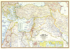
This map of the Lands of the Bible contains a large quantity of ancient historical information as well as details of significant events of the time. Published in December 1967 with three articles including "Eyewitness to War in the Holy Land," this map outlines the territory occupied by Israel in June of 1967 during the Six Days War between Israel and neighboring Arab countries.

The 1967 Lands of the Bible Today map features:
• Walled City of Jerusalem inset with the way of the cross from Pilates hall of judgment to Calvary
• Historical insets showing the traditional route of the Exodus, St. Pauls four great journeys, and the Crusades
• A detailed inset map of the Holy Land in 1967
• Copious historical information with notes referencing revelant Biblical passages, and locations of the Seven Wonders of the Ancient World.
• An abundance of place names including capitals, cities, and towns, and transportation routes including roads, railroads, airfields, and canals
• Geographical details including mountains, lakes, intermittent lakes, dry lakes, rivers, deserts, volcanic debris, water holes, and areas below sea level
• Oil fields, pipelines, and pumping stations

Coverage Area: Greece, Turkey, Cyprus, Iraq, Syria, western Iran, Lebanon, Israel, Jordan, Kuwait, northeastern Egypt, northern Saudi Arabia

More Product Details

This map requires 7 business days to print and laminate prior to shipping.

Appearing in the December 1967 issue of the National Geographic Magazine, this Lands Of The Bible Today map has been reproduced from its original cartography in order to bring to life a beautiful poster previously only seen in National Geographic Magazine. This reproduction holds true to the high standards that National Geographic Maps are known for.

Perfect for home, office or classroom, this map also makes a great gift. Map collectors will surely want to add this map to their library.

The Paper version is printed on high quaility semi-gloss paper, perfect for framing.

The Laminated version uses 3mm laminate on both sides for durability, is easy to clean and markable.

From the National Geographic Classic Maps collection, this reproduction is just one of hundreds of titles available here. These maps are Printed on Demand. Sizes are approximate and may vary due to the nature of the trimming and laminating processes.
Shipping Conditions
Maps.com ships to Dometic US only

US FlagThis product can only be shipped to the Domestic U.S.A. (No APO's or PO Boxes)
TimeThis map requires 2 business days to print and laminate prior to shipping.