 |
|
|
|
|
Special Places Of The World, Holy Land Map 1989 Side 1
Issue: December 1989
|
|
|
|
|
|
|
| Product Highlights |
| Special Places Of The World, Holy Land Map 1989 Side 1 |
| Item#: X NGC 121989a |
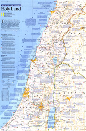
Half of a two-page layout on the Holy Land, this map demonstrates the beautiful cartography that National Geographic is known for combined with copious historical, religious, and geographical facts about this land of faith and conflict. Printed in December 1989, this work is noteworthy on its own or accompanied by the other half of the feature. The 1989 "Special Places of the World, Holy Land" map side 1 features:
• Sites are noted by historical period, from Stone and Bronze Ages (CA 500,000 to 1200 B.C.) to the Islamic Period (A.D. 640 to 1917)
• Sites are marked with symbols to denote the religions associated with that site
• An abundance of historical and geographical information
• Unusual sites not found on other maps including Israeli settlements, refugee camps, and cedar groves
• Capitals, cities, and towns
• Highways, main roads, secondary roads, unpaved roads or tracks, railroads, canals, and scheduled air service
• Geographical details including mountains, rivers, lakes, lava, and areas below sea level
Coverage Area: Lebanon, western Syria, Israel, western Jordan
|
|
 |
More Product Details
This map requires 7 business days to print and laminate prior to shipping.
Appearing in the December 1989 issue of the National Geographic Magazine, this Special Places Of The World, Holy Land map has been reproduced from its original cartography in order to bring to life a beautiful poster previously only seen in National Geographic Magazine. This reproduction holds true to the high standards that National Geographic Maps are known for.
Perfect for home, office or classroom, this map also makes a great gift. Map collectors will surely want to add this map to their library.
The Paper version is printed on high quaility semi-gloss paper, perfect for framing.
The Laminated version uses 3mm laminate on both sides for durability, is easy to clean and markable.
From the National Geographic Classic Maps collection, this reproduction is just one of hundreds of titles available here. These maps are Printed on Demand. Sizes are approximate and may vary due to the nature of the trimming and laminating processes.
|
|
Shipping Conditions
Maps.com ships to Dometic US only
 | This product can only be shipped to the Domestic U.S.A. (No APO's or PO Boxes) |  | This map requires 2 business days to print and laminate prior to shipping. |
|
|
|
|


 Click here to zoom!