 |
|
|
|
|
British Columbia, Alberta And The Yukon Territory Map
Issue: April 1978
|
|
|
|
|
|
|
| Product Highlights |
| British Columbia, Alberta And The Yukon Territory Map |
| Item#: X NGC 041978b |
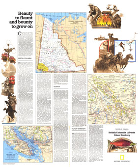
Published in April 1978 as half of a two-map set showcasing Canada's western provinces, the "British Columbia, Alberta, Yukon Territory: Beauty to Flaunt and Bounty to Grown On" map provides a remarkable amount of information about the history and unique sites which make the region a popular tourist destination. Together, the two maps accompanied the article "Yukon Fever: Call of the North." The 1978 Canada, British Columbia, Alberta and the Yukon Territory map features:
• Inset map of Canada's Rocky Mountain parks
• Map of the Yukon Territory
• Detailed inset map of Victoria and Vancouver
• Informative articles on the history and tourist activities to be found in the three provinces
• Colorful illustrations
Coverage Area: British Columbia, Alberta, Yukon Territory
|
|
 |
More Product Details
This map requires 7 business days to print and laminate prior to shipping.
Appearing in the April 1978 issue of the National Geographic Magazine, this Close Up Canada British Columbia, Alberta And The Yukon Territory map has been reproduced from its original cartography in order to bring to life a beautiful poster previously only seen in National Geographic Magazine. This reproduction holds true to the high standards that National Geographic Maps are known for.
Perfect for home, office or classroom, this map also makes a great gift. Map collectors will surely want to add this map to their library.
The Paper version is printed on high quaility semi-gloss paper, perfect for framing.
The Laminated version uses 3mm laminate on both sides for durability, is easy to clean and markable.
From the National Geographic Classic Maps collection, this reproduction is just one of hundreds of titles available here. These maps are Printed on Demand. Sizes are approximate and may vary due to the nature of the trimming and laminating processes.
|
|
Shipping Conditions
Maps.com ships to Dometic US only
 | This product can only be shipped to the Domestic U.S.A. (No APO's or PO Boxes) |  | This map requires 2 business days to print and laminate prior to shipping. |
|
|
|
|


 Click here to zoom!