 |
|
|
|
|
British Columbia Map 1992 Side 2
Issue: April 1992
|
|
|
|
|
|
|
| Product Highlights |
| British Columbia Map 1992 Side 2 |
| Item#: X NGC 041992b |
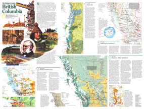
Published in April 1992 as half of a two-map set, this map of British Columbia is part of the "Making of Canada" series. With a collection of maps detailing periods of the province's exploration and settlement, this work provides a wonderful historical overview as well as a compelling look at the wonders of present-day British Columbia. The 1992 British Columbia map Side 2 features:
• Information on native life in British Columbia, ca 1775 and a map showing linguistic families, trade items, and trade routes
• A section on the exploration of the northwest including a map showing fur trading posts, major maritime trade centers, fur trade routes, explorer's routes, and native groups
• Maps and information on the gold rush and the fur trade
• Information on the settlement of the region from 1846-1940 including a map showing immigrant routes, natural resources, farming and grazing areas, railroads, hydroelectric sites, and more
• Map of present day British Columbia showing population density, recreational activities, national parks, and natural resources
• Inset map of Vancouver
• Colorful illustrations
Coverage Area: British Columbia
|
|
 |
More Product Details
This map requires 7 business days to print and laminate prior to shipping.
Appearing in the April 1992 issue of the National Geographic Magazine, this British Columbia map has been reproduced from its original cartography in order to bring to life a beautiful poster previously only seen in National Geographic Magazine. This reproduction holds true to the high standards that National Geographic Maps are known for.
Perfect for home, office or classroom, this map also makes a great gift. Map collectors will surely want to add this map to their library.
The Paper version is printed on high quaility semi-gloss paper, perfect for framing.
The Laminated version uses 3mm laminate on both sides for durability, is easy to clean and markable.
From the National Geographic Classic Maps collection, this reproduction is just one of hundreds of titles available here. These maps are Printed on Demand. Sizes are approximate and may vary due to the nature of the trimming and laminating processes.
|
|
Shipping Conditions
Maps.com ships to Dometic US only
 | This product can only be shipped to the Domestic U.S.A. (No APO's or PO Boxes) |  | This map requires 2 business days to print and laminate prior to shipping. |
|
|
|
|


 Click here to zoom!