SHOP BY YEAR :: FOR OFFICE :: FOR CLASSROOM :: GIFT IDEAS :: CUSTOMER SERVICE

Saskatchewan And Manitoba Canada Map 1979
Issue: May 1979
More Views
Enlarge Image
ZoomClick here to zoom!
Purchase Product :
Please select map format:
Laminated   
22.5" x 29" - $39.95
Laminated-w/Plastic Rails  (What are rails?)
22.5" x 29" - $51.95
Paper
22.5" x 29" - $29.95
Wallzilla Adhesive Format
22.5" x 29" - $59.95
Product Highlights
Saskatchewan And Manitoba Canada Map 1979
Item#: X NGC 051979a

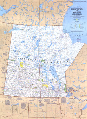
Half of a two-map set, this map of Saskatchewan and Manitoba is a wonderful travel map with points of interest in cities such as Winnipeg and Regina, as well as hundreds of national parks, wilderness areas, campgrounds, and ski resorts. Published in May 1979, its companion map features additional information on these lovely provinces.

The 1979 Saskatchewan and Manitoba map features:
• A list of sites and events in many tourist destinations
• Ski areas and points of interest
• Indian reserves, national parks, national wildlife reserves, wilderness areas, and provincial and territorial parks, campgrounds and historic parks
• Capitals, cities, and towns
• Roads, passenger railroads, and airports
• Mountains, rivers, lakes, swamps, sand, and drainage divides

Coverage Area: Saskatchewan, Manitoba

More Product Details

This map requires 7 business days to print and laminate prior to shipping.

Appearing in the May 1979 issue of the National Geographic Magazine, this Saskatchewan And Manitoba Canada map has been reproduced from its original cartography in order to bring to life a beautiful poster previously only seen in National Geographic Magazine. This reproduction holds true to the high standards that National Geographic Maps are known for.

Perfect for home, office or classroom, this map also makes a great gift. Map collectors will surely want to add this map to their library.

The Paper version is printed on high quaility semi-gloss paper, perfect for framing.

The Laminated version uses 3mm laminate on both sides for durability, is easy to clean and markable.

From the National Geographic Classic Maps collection, this reproduction is just one of hundreds of titles available here. These maps are Printed on Demand. Sizes are approximate and may vary due to the nature of the trimming and laminating processes.
Shipping Conditions
Maps.com ships to Dometic US only

US FlagThis product can only be shipped to the Domestic U.S.A. (No APO's or PO Boxes)
TimeThis map requires 2 business days to print and laminate prior to shipping.