SHOP BY YEAR :: FOR OFFICE :: FOR CLASSROOM :: GIFT IDEAS :: CUSTOMER SERVICE

Northwestern United States and Canadian Provinces Map 1941
Issue: June 1941
More Views
Enlarge Image
ZoomClick here to zoom!
Purchase Product :
Please select map format:
Laminated   
36" x 24" - $39.95
Laminated-w/Plastic Rails  (What are rails?)
36" x 24" - $51.95
Paper
36" x 24" - $29.95
Wallzilla Adhesive Format
36" x 24" - $59.95
Product Highlights
Northwestern United States and Canadian Provinces Map 1941
Item#: X NGC 061941

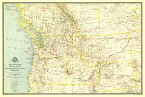
The map of Northwestern United States and Neighboring Canadian Provinces appeared in National Geographic Magazine in June of 1941 and focused on the states of Washington, Oregon, Idaho, Montana, and Wyoming, and the southern portion of the provinces of British Columbia, Alberta, and Saskatchewan. It contains an abundance of notes on historical sites and places of interest as well as the routes of explorers.

The 1941 Northwestern United States and Neighboring Canadian Provinces map features:
• Exploration routes
• Notes on historical sites and places of interest
• State capitals, cities, and towns
• National parks and monuments, Indian reservations, reclamation projects, and battlefields
• Highways and railways
• Mountain ranges, major rivers, and major lakes

Coverage Area: Washington, Oregon, Idaho, Montana, Wyoming, southern British Columbia, southern Alberta, southern Saskatchewan

More Product Details

This map requires 7 business days to print and laminate prior to shipping.

Appearing in the June 1941 issue of the National Geographic Magazine, this Northwestern United States and Neighboring Canadian Provinces map has been reproduced from its original cartography in order to bring to life a beautiful poster previously only seen in National Geographic Magazine. This reproduction holds true to the high standards that National Geographic Maps are known for.

Perfect for home, office or classroom, this map also makes a great gift. Map collectors will surely want to add this map to their library.

The Paper version is printed on high quaility semi-gloss paper, perfect for framing.

The Laminated version uses 3mm laminate on both sides for durability, is easy to clean and markable.

From the National Geographic Classic Maps collection, this reproduction is just one of hundreds of titles available here. These maps are Printed on Demand. Sizes are approximate and may vary due to the nature of the trimming and laminating processes.
Shipping Conditions
Maps.com ships to Dometic US only

US FlagThis product can only be shipped to the Domestic U.S.A. (No APO's or PO Boxes)
TimeThis map requires 2 business days to print and laminate prior to shipping.