SHOP BY YEAR :: FOR OFFICE :: FOR CLASSROOM :: GIFT IDEAS :: CUSTOMER SERVICE

Tidewater And Environs Map 1988 Side 1
Issue: June 1988
More Views
Enlarge Image
ZoomClick here to zoom!
Purchase Product :
Please select map format:
Laminated   
20" x 27" - $39.95
Laminated-w/Plastic Rails  (What are rails?)
20" x 27" - $51.95
Paper
20" x 27" - $29.95
Wallzilla Adhesive Format
20" x 27" - $59.95
Product Highlights
Tidewater And Environs Map 1988 Side 1
Item#: X NGC 061988a

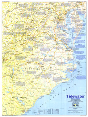
The Tidewater and Environs map contains an abundance of historical notes and sites throughout the Carolinas, Virginia, and neighboring states. Published in June 1988, this map is half of a two-map set in the "Making of America" series.

The 1988 Tidewater and Environs map Side 1 features:
• An abundance of historical notes
• National parks, battlefields, mining areas, and sites
• Capitals, cities, and towns
• Intracoastal waterways and ferry routes
• Interstate highways, major roads, other roads, passenger railroads, trails, canals, and scheduled air service
• Mountain relief, rivers, lakes, and swamps

Coverage Area: South Carolina, North Carolina, Virginia, West Virginia, Maryland, Delaware, District of Columbia

More Product Details

This map requires 7 business days to print and laminate prior to shipping.

Appearing in the June 1988 issue of the National Geographic Magazine, this Tidewater And Environs map Side 1 has been reproduced from its original cartography in order to bring to life a beautiful poster previously only seen in National Geographic Magazine. This reproduction holds true to the high standards that National Geographic Maps are known for.

Perfect for home, office or classroom, this map also makes a great gift. Map collectors will surely want to add this map to their library.

The Paper version is printed on high quaility semi-gloss paper, perfect for framing.

The Laminated version uses 3mm laminate on both sides for durability, is easy to clean and markable.

From the National Geographic Classic Maps collection, this reproduction is just one of hundreds of titles available here. These maps are Printed on Demand. Sizes are approximate and may vary due to the nature of the trimming and laminating processes.
Shipping Conditions
Maps.com ships to Dometic US only

US FlagThis product can only be shipped to the Domestic U.S.A. (No APO's or PO Boxes)
TimeThis map requires 2 business days to print and laminate prior to shipping.