SHOP BY YEAR :: FOR OFFICE :: FOR CLASSROOM :: GIFT IDEAS :: CUSTOMER SERVICE

Yukon And Northwest Territories Map 1997
Issue: September 1997
More Views
Enlarge Image
ZoomClick here to zoom!
Purchase Product :
Please select map format:
Laminated   
27" x 20.5" - $39.95
Laminated-w/Plastic Rails  (What are rails?)
27" x 20.5" - $51.95
Paper
27" x 20.5" - $29.95
Wallzilla Adhesive Format
27" x 20.5" - $59.95
Product Highlights
Yukon And Northwest Territories Map 1997
Item#: X NGC 091997a

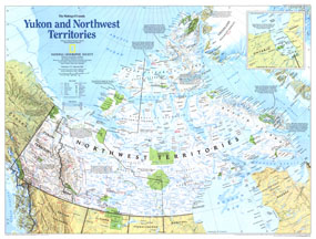
A new era of change was occurring in Canada's northernmost reaches as this map came to print in September 1997. With the creation of Nunavut, a homeland for the Inuit people, the country would gain a new province in April of 1999. Part of the "Making of Canada" series and half of a two-map set on the region, this map of the Yukon and Northwest Territories highlights historical sites and the abundant national and territorial parks and wildlife areas.

The 1997 Yukon and Northwest Territories map features:
• Inset map of Nunavut
• Geographical and historical notes
• Mountains, rivers, lakes, swamps, and glacier or ice fields
• Roads, winter roads, passenger railroads, airports, and airfields
• Indian reserves, wildlife areas, national parks, and territorial parks
• Oil fields and pipelines
• Northern limit of wooded country

Coverage Area: Yukon Territory, Northwest Territories

More Product Details

This map requires 7 business days to print and laminate prior to shipping.

Appearing in the September 1997 issue of the National Geographic Magazine, this Yukon And Northwest Territories map has been reproduced from its original cartography in order to bring to life a beautiful poster previously only seen in National Geographic Magazine. This reproduction holds true to the high standards that National Geographic Maps are known for.

Perfect for home, office or classroom, this map also makes a great gift. Map collectors will surely want to add this map to their library.

The Paper version is printed on high quaility semi-gloss paper, perfect for framing.

The Laminated version uses 3mm laminate on both sides for durability, is easy to clean and markable.

From the National Geographic Classic Maps collection, this reproduction is just one of hundreds of titles available here. These maps are Printed on Demand. Sizes are approximate and may vary due to the nature of the trimming and laminating processes.
Shipping Conditions
Maps.com ships to Dometic US only

US FlagThis product can only be shipped to the Domestic U.S.A. (No APO's or PO Boxes)
TimeThis map requires 2 business days to print and laminate prior to shipping.