SHOP BY YEAR :: FOR OFFICE :: FOR CLASSROOM :: GIFT IDEAS :: CUSTOMER SERVICE

Atlantic Canada Map Side 2 1993
Issue: October 1993
More Views
Enlarge Image
ZoomClick here to zoom!
Purchase Product :
Please select map format:
Laminated   
27" x 20.5" - $39.95
Laminated-w/Plastic Rails  (What are rails?)
27" x 20.5" - $51.95
Paper
27" x 20.5" - $29.95
Wallzilla Adhesive Format
27" x 20.5" - $59.95
Product Highlights
Atlantic Canada Map Side 2 1993
Item#: X NGC 101993b

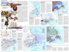
Published in October 1993 as half of a two-map set, this map of Atlantic Canada is part of the "Making of Canada" series. With a collection of maps detailing periods of the region's exploration and settlement as well as information about its dwindling fishing industry and burgeoning tourism industry, this work provides a wonderful historical overview as well as a compelling look at the changing face of Atlantic Canada.

The 1993 Atlantic Canada map Side 2 features:
• A map showing the exploration of the region including principal explorers' routes, European inshore fisheries, whaling stations, tribal groups, Norse place names, and more
• A map detailing the struggle for power between England and France including settlements, disputed areas, forts, and more
• Information and a map showing the dominent ethnic settlements in the mid-19th century
• Details of the region's industry from 1868-1938 including fishing, lumber, manufacturing, mining, and more
• A map showing present-day economic information including fish processing centers, fishing moratorium areas, hydroelectric power stations, gas and oil fields, and more
• A map featuring tourist activities including sport fishing, ski resorts, scenic drives, national parks, campgrounds, and more
• Population graphs and illustrations

Coverage Area: Newfoundland, Labrador, Nova Scotia, New Brunswick, Prince Edward Island, eastern Quebec

More Product Details

This map requires 7 business days to print and laminate prior to shipping.

Appearing in the October 1993 issue of the National Geographic Magazine, this Atlantic Canada map has been reproduced from its original cartography in order to bring to life a beautiful poster previously only seen in National Geographic Magazine. This reproduction holds true to the high standards that National Geographic Maps are known for.

Perfect for home, office or classroom, this map also makes a great gift. Map collectors will surely want to add this map to their library.

The Paper version is printed on high quaility semi-gloss paper, perfect for framing.

The Laminated version uses 3mm laminate on both sides for durability, is easy to clean and markable.

From the National Geographic Classic Maps collection, this reproduction is just one of hundreds of titles available here. These maps are Printed on Demand. Sizes are approximate and may vary due to the nature of the trimming and laminating processes.
Shipping Conditions
Maps.com ships to Dometic US only

US FlagThis product can only be shipped to the Domestic U.S.A. (No APO's or PO Boxes)
TimeThis map requires 2 business days to print and laminate prior to shipping.