 |
|
|
|
|
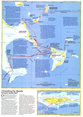
Threading The Islands Map 1986
Issue: November 1986
|
|
|
|
|
|
|
| Product Highlights |
| Threading The Islands Map 1986 |
| Item#: X NGC 111986b |
The "Threading the Islands" map explores two possible routes of Columbus's journey and possible landing sites. The Morisson track asserts that the explorer landed on San Salvador, while the Judge track favors Samana Cay. This map was printed in November 1986 to accompany three articles on Columbus and the "Where Did Columbus Discover America?" map. A fascinating new look at a centuries-old question. The 1986 "Threading the Islands" map features:
• An introduction explaining the two theories
• Both the Morisson and Judge tracks, with notes on each point
• Nautical miles between points and speed noted
• An inset map of Samana Cay detailing points that make it the more compelling landing point, including notes from Columbus's logs
• Anchorage points, Columbus monuments, and selected Lucayan Indian sites
• Ocean bathymetry and currents
Coverage Area: San Salvador Island, Samana Cay, Bahamas
|
|
 |
More Product Details
This map requires 7 business days to print and laminate prior to shipping.
Appearing in the November 1986 issue of the National Geographic Magazine, this Threading The Islands map has been reproduced from its original cartography in order to bring to life a beautiful poster previously only seen in National Geographic Magazine. This reproduction holds true to the high standards that National Geographic Maps are known for.
Perfect for home, office or classroom, this map also makes a great gift. Map collectors will surely want to add this map to their library.
The Paper version is printed on high quaility semi-gloss paper, perfect for framing.
The Laminated version uses 3mm laminate on both sides for durability, is easy to clean and markable.
From the National Geographic Classic Maps collection, this reproduction is just one of hundreds of titles available here. These maps are Printed on Demand. Sizes are approximate and may vary due to the nature of the trimming and laminating processes.
|
|
Shipping Conditions
Maps.com ships to Dometic US only
 | This product can only be shipped to the Domestic U.S.A. (No APO's or PO Boxes) |  | This map requires 2 business days to print and laminate prior to shipping. |
|
|
|
|


 Click here to zoom!