SHOP BY YEAR :: FOR OFFICE :: FOR CLASSROOM :: GIFT IDEAS :: CUSTOMER SERVICE

West Indies Map 1987 Side 1
Issue: November 1987
More Views
Enlarge Image
ZoomClick here to zoom!
Purchase Product :
Please select map format:
Laminated   
27" x 20.5" - $39.95
Laminated-w/Plastic Rails  (What are rails?)
27" x 20.5" - $51.95
Paper
27" x 20.5" - $29.95
Wallzilla Adhesive Format
27" x 20.5" - $59.95
Product Highlights
West Indies Map 1987 Side 1
Item#: X NGC 111987a

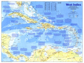
Explore the culturally diverse and historically rich islands of the Caribbean with this map of the West Indies. Part of the "Making of America" series, this map represents Side One of a two-map set published in November 1987. Two articles, "Searching for Columbus's Lost Colony: La Navidad" and "Haiti - Against All Odds," accompanied the two maps.

The 1987 West Indies map Side 1 features:
• An abundance of historical notes
• US national parks, Indian reservations or reserves, battlefields, ruins, and sites
• Capitals, cities, and towns
• Ocean bathymetry, mountain relief, rivers, reefs, and swamps
• Interstate highways, roads, passenger railroads, and scheduled air service
• Political administration
• Geographical equivalents

Coverage Area: West Indies, Panama, Costa Rica, Nicaragua, northern Columbia, northern Venezuela

More Product Details

This map requires 7 business days to print and laminate prior to shipping.

Appearing in the November 1987 issue of the National Geographic Magazine, this West Indies map Side 1has been reproduced from its original cartography in order to bring to life a beautiful poster previously only seen in National Geographic Magazine. This reproduction holds true to the high standards that National Geographic Maps are known for.

Perfect for home, office or classroom, this map also makes a great gift. Map collectors will surely want to add this map to their library.

The Paper version is printed on high quaility semi-gloss paper, perfect for framing.

The Laminated version uses 3mm laminate on both sides for durability, is easy to clean and markable.

From the National Geographic Classic Maps collection, this reproduction is just one of hundreds of titles available here. These maps are Printed on Demand. Sizes are approximate and may vary due to the nature of the trimming and laminating processes.
Shipping Conditions
Maps.com ships to Dometic US only

US FlagThis product can only be shipped to the Domestic U.S.A. (No APO's or PO Boxes)
TimeThis map requires 2 business days to print and laminate prior to shipping.