 |
|
|
|
|
Visitors Guide To The Aztec World Map 1980
Issue: December 1980
|
|
|
|
|
|
|
| Product Highlights |
| Visitors Guide To The Aztec World Map 1980 |
| Item#: X NGC 121980b |
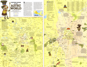
Discover the intriguing world of the ancient Aztecs with the "Visitor's Guide to the Aztec World" map. Published in December 1980, this map appeared as a companion to the map of Mexico and Central America and two articles on the Aztecs. Filled with a wealth of information about archaeological sites and a modern map of Mexico City, this piece is perfect for travelers or those interested in the ancient civilizations. The 1980 Visitors Guide to the Aztec World map features:
• Detailed map of the Valley of Mexico
• Map of Mexico City with modern points of interest such as Metro stations, public buildings, hospitals, and shopping areas, as well as archaeological sites within the city
• Inset map showing the extent of the Aztec World
• Index to places of interest
• A historical introduction
• Archaeological sites, the route of Cortes, ancient causeways, aqueducts, national parks, campgrounds, and more
• Notes about a variety of archaeological sites
Coverage Area: Mexico
|
|
 |
More Product Details
This map requires 7 business days to print and laminate prior to shipping.
Appearing in the December 1980 issue of the National Geographic Magazine, this Visitors Guide To The Aztec World map has been reproduced from its original cartography in order to bring to life a beautiful poster previously only seen in National Geographic Magazine. This reproduction holds true to the high standards that National Geographic Maps are known for.
Perfect for home, office or classroom, this map also makes a great gift. Map collectors will surely want to add this map to their library.
The Paper version is printed on high quaility semi-gloss paper, perfect for framing.
The Laminated version uses 3mm laminate on both sides for durability, is easy to clean and markable.
From the National Geographic Classic Maps collection, this reproduction is just one of hundreds of titles available here. These maps are Printed on Demand. Sizes are approximate and may vary due to the nature of the trimming and laminating processes.
|
|
Shipping Conditions
Maps.com ships to Dometic US only
 | This product can only be shipped to the Domestic U.S.A. (No APO's or PO Boxes) |  | This map requires 2 business days to print and laminate prior to shipping. |
|
|
|
|


 Click here to zoom!