SHOP BY YEAR :: FOR OFFICE :: FOR CLASSROOM :: GIFT IDEAS :: CUSTOMER SERVICE

Pilot Chart Of The North Atlantic Ocean Map 1903
Issue: February 1903
More Views
Enlarge Image
ZoomClick here to zoom!
Purchase Product :
Please select map format:
Laminated   
34" x 24" - $39.95
Laminated-w/Plastic Rails  (What are rails?)
34" x 24" - $51.95
Paper
34" x 24" - $29.95
Wallzilla Adhesive Format
34" x 24" - $59.95
Product Highlights
Pilot Chart Of The North Atlantic Ocean Map 1903
Item#: X NGC 021903

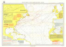
The Pilot Chart of the North Atlantic Ocean is a fascinating historical piece which appeared in National Geographic Magazine in February 1903, a time when all travel and trade across the Atlantic was done by boat. It contains recommended routes for steamships, branch hydrographic offices, and a wealth of information about weather patterns over the ocean including storm and gale signals, cyclonic storm tracks, fog reports and more. A truly unique map for collectors.

The 1903 Pilot Chart of the North Atlantic Ocean map features:
• Isobars and isotherms for the month of February
• Gale and storm signals
• Tracks of cyclonic storms in February from 1897 to 1902
• Gale and fog reports
• Charts published, canceled, and extensively corrected from December 31, 1902 to January 30, 1903
• Recommended routes for full and low powered steamships
• Derelicts and wrecks, icebergs and field ice, drifting buoys, waterspouts, and regions of frequent fog

Coverage Area: North Atlantic Ocean, North American coastline, Newfoundland, Nova Scotia, Central America, West Indies, Ireland, British Isles, European coastline, North African coastline, Canary Islands

More Product Details

This map requires 7 business days to print and laminate prior to shipping.

Appearing in the February 1903 issue of the National Geographic Magazine, this Pilot Chart Of The North Atlantic Ocean map has been reproduced from its original cartography in order to bring to life a beautiful poster previously only seen in National Geographic Magazine. This reproduction holds true to the high standards that National Geographic Maps are known for.

The Paper version is printed on high quaility semi-gloss paper, perfect for framing.

The Laminated version uses 3mm laminate on both sides for durability, is easy to clean and markable.

From the National Geographic Classic Maps collection, this reproduction is just one of hundreds of titles available here. These maps are Printed on Demand. Sizes are approximate and may vary due to the nature of the trimming and laminating processes.
Shipping Conditions
Maps.com ships to Dometic US only

US FlagThis product can only be shipped to the Domestic U.S.A. (No APO's or PO Boxes)
TimeThis map requires 2 business days to print and laminate prior to shipping.