SHOP BY YEAR :: FOR OFFICE :: FOR CLASSROOM :: GIFT IDEAS :: CUSTOMER SERVICE

Northwestern South America Map 1964
Issue: February 1964
More Views
Enlarge Image
ZoomClick here to zoom!
Purchase Product :
Please select map format:
Laminated   
19" x 25" - $19.95
Laminated-w/Plastic Rails  (What are rails?)
19" x 25" - $29.95
Paper
19" x 25" - $14.95
Wallzilla Adhesive Format
19" x 25" - $34.95
Product Highlights
Northwestern South America Map 1964
Item#: X NGC 021964

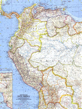
The Northwestern South America map was published in National Geographic Magazine in February 1964 with the article "The Five Worlds of Peru." It features inset maps of the cities of Bogota, Caracas, and Lima. A fine companion to the map of Eastern South America printed in 1962.

The 1964 Northwestern South America map features:
• Inset maps of Bogota, Caracas, and Lima
• Capitals, cities, and towns
• Pan American Highway system, roads, railroads, canals, and places with scheduled air service
• Mountains, rivers, lakes, dry salt lakes, intermittent lakes, glaciers, and sand
• Ocean bathymetry, warm currents, and cold currents
• Ruins
• Oil fields and pipelines

Coverage Area: Panama, Columbia, Venezuela, British Guiana, Surinam (Dutch Guiana), Ecuador, Bolivia, Peru, western Brazil, northern Paraguay

More Product Details

This map requires 7 business days to print and laminate prior to shipping.

Appearing in the February 1964 issue of the National Geographic Magazine, this Northwestern South America map has been reproduced from its original cartography in order to bring to life a beautiful poster previously only seen in National Geographic Magazine. This reproduction holds true to the high standards that National Geographic Maps are known for.

Perfect for home, office or classroom, this map also makes a great gift. Map collectors will surely want to add this map to their library.

The Paper version is printed on high quaility semi-gloss paper, perfect for framing.

The Laminated version uses 3mm laminate on both sides for durability, is easy to clean and markable.

From the National Geographic Classic Maps collection, this reproduction is just one of hundreds of titles available here. These maps are Printed on Demand. Sizes are approximate and may vary due to the nature of the trimming and laminating processes.
Shipping Conditions
Maps.com ships to Dometic US only

US FlagThis product can only be shipped to the Domestic U.S.A. (No APO's or PO Boxes)
TimeThis map requires 2 business days to print and laminate prior to shipping.