 |
|
|
|
|
Earths Moon Map 1969
Issue: February 1969
|
|
|
|
|
|
|
| Product Highlights |
| Earths Moon Map 1969 |
| Item#: X NGC 021969 |
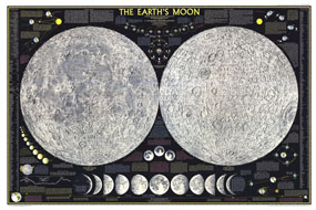
Explore the moon in striking detail with this educational map published in February 1969. Featuring detailed illustrations of both the near and far sides of the moon, this map also contains an abundance of illustrations and information about the moon including its physical properties and features, phases, eclipses, orbital paths, and the Apollo mission. The 1969 Earths Moon map features:
• Illustrations of the near and far sides of the moon including all the named features
• The physical properties and features of the moon
• Illustrations and information about the lunar month and the phases of the moon, eclipses, libration, orbital paths, the tides, moon lore, and more
• Information and illustrations about the Apollo mission
• Moon comparisons and planet to satellite size ratio
• Profile of a crater showing Copernicus, an average moon crater, in comparison to the Grand Canyon
Coverage Area: Moon
|
|
 |
More Product Details
This map requires 7 business days to print and laminate prior to shipping.
Appearing in the February 1969 issue of the National Geographic Magazine, this Earths Moon map has been reproduced from its original cartography in order to bring to life a beautiful poster previously only seen in National Geographic Magazine. This reproduction holds true to the high standards that National Geographic Maps are known for.
Perfect for home, office or classroom, this map also makes a great gift. Map collectors will surely want to add this map to their library.
The Paper version is printed on high quaility semi-gloss paper, perfect for framing.
The Laminated version uses 3mm laminate on both sides for durability, is easy to clean and markable.
From the National Geographic Classic Maps collection, this reproduction is just one of hundreds of titles available here. These maps are Printed on Demand. Sizes are approximate and may vary due to the nature of the trimming and laminating processes.
|
|
Shipping Conditions
Maps.com ships to Dometic US only
 | This product can only be shipped to the Domestic U.S.A. (No APO's or PO Boxes) |  | This map requires 2 business days to print and laminate prior to shipping. |
|
|
|
|


 Click here to zoom!